I am not maintaining this site any longer. All these, plus my most up to date posts can be found at:
ofthewoods61.blogspot.com/
Kevin

I am not maintaining this site any longer. All these, plus my most up to date posts can be found at:
ofthewoods61.blogspot.com/
Kevin
Will, JC, and I took a weekend trip to the Tidewater Appalachian Trail Club cabin
(http://www.tidewateratc.com/tatc/pages/cabin_picture.html) to do some hiking, but also to plan for a big fall trip.
JC and I picked up Will in Richmond at the REI and then Will drove us west. We stopped at the Blue Mountain Brewery for dinner and a pint. Tasty! (http://www.bluemountainbrewery.com)
On this winter day, the Blue Ridge Parkway was closed so we had to park as close to the Parkway and cabin trailhead as we could get. The Royal Oaks Cabins in Love, VA
(http://www.vacabins.com) was kind enough to let us park at their facility and then it was another 2.5 miles to the trailhead and another 0.5 miles to the cabin. The weather was cold, but we were excited to get to the cabin. The walk on Parkway road was easy and there was not much snow or ice to contend with. We made it to the trailhead and lugged in all of our extra gear – books and maps, brews and stew fixings, extra clothes, lanterns and propane tanks, eggs and bacon and sausage.
Once at the cabin, we got a good fire going in the fireplace. Lighting the wood-burning cook stove was another matter. We struggled with the outdoor chamber in the chimney to get the proper draft, and generally made a smoky mess of things until we finally gave up at midnight.
It was a cold night in the cabin. We awoke to find it was 8 degrees Fahrenheit outside and only 26 degrees inside! It was frickin COLD!
We cooked a big breakfast on the Coleman stove with propane tanks. We ate all the eggs, bacon, and sausage we had. We boiled water for coffee and hot chocolate.
After breakfast we decided to warm up a bit by replenishing the wood we had burned the night before. We hauled wood up from a lower pile and Will demonstrate his splitting prowess. We put back more than we burned, packed up and started our hike at around 11:00.
We had hoped to hike around 5 miles on the White Rock Falls, Slacks Trail, and White Rock Gap Trails and do a little trout fishing along the way. However, with the temps hovering in the single digits, I was betting it would just be casting practice. 
Here we are at the start of the White Rock Falls Trail- Will with blaze orange accents.

As we walked along the trail, there were all these beautiful little ice pillars formed by the freezing and thawing of the snow and ground. It was a pity to crush them as we went.

The White Rock Falls trail was very nice, following along White Rock Creek for quite a distance. Keeping an eye out for nice runs and pools, we finally spotted one for Will to try his casting skills with the Scott 3 wt. They were beautiful, but pool after pool we did not get any taps.

And so it went as we hiked and fished, hiked and fished. On our ascent to cross the parkway to the Slacks Trail, it began to snow and we talked about leaving early so we wouldn’t need to spend another freezing night in the cabin and potentially get stuck trying to get out on a country road.

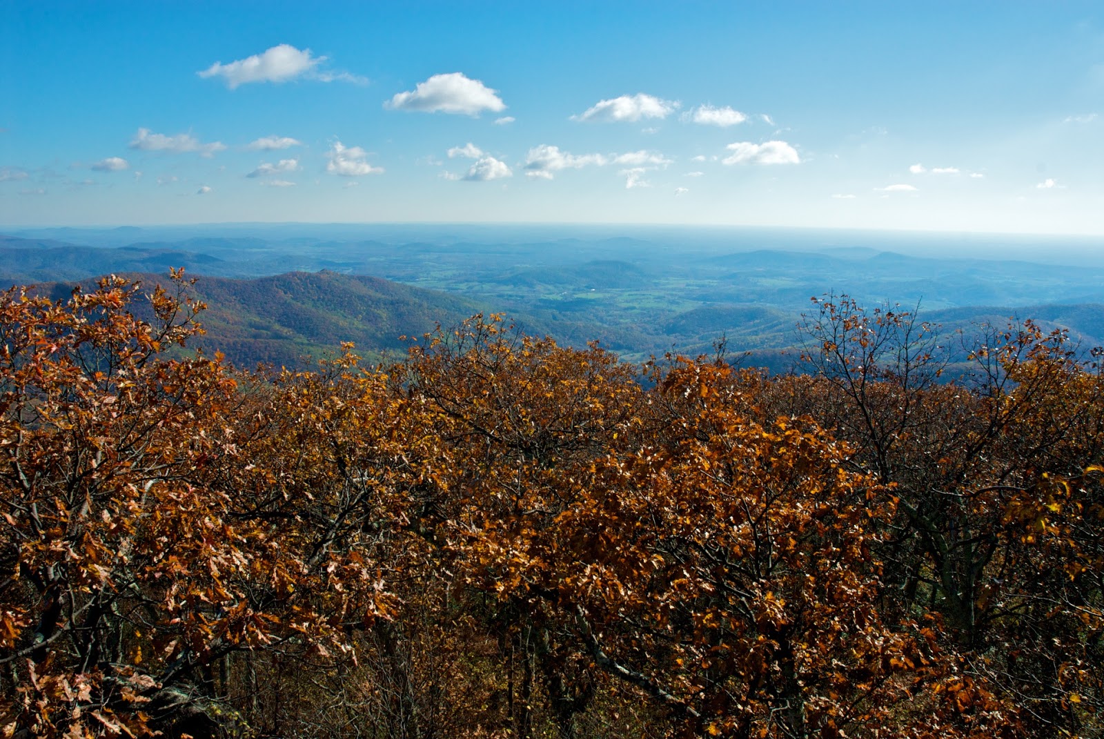
Cold and snowing, we had some beautiful views of the mountains all to ourselves. Snow and ice on these rock outcroppings kept me from trying to get this view without the trees in the way.

We were moving now with purpose and by the time we reached the Blue Ridge Parkway, the snow was coming at us sideways at about 20 mph. We made it back to the cabin, hurriedly packed up and cleaned up the cabin and made our way back down the trailhead. We hiked the seemingly longer 2.5 miles out and back to the Royal Oaks Cabins in Love. We were happy to see Will’s Honda and even happier to see the camp store open so we ducked in to thank the proprietor and get some drinks and snacks for the ride home.
After some pleasant conversation we hit the road and Will turned the Honda for Richmond. After a brief stop for some soup, we made it back to Will’s house, ate dinner, and discussed plans for a big fall trip to the Pisgah National Forest. We were pretty tired from the cold, short sleep Friday night and the hiking on Saturday so our discussion was only half-heated as our lids grew heavy. Sleep came easily.
The next morning, we had a hearty breakfast, bored JC with all our talk of fly fishing, and finally bade Will farewell as JC and I headed for the barn.
The cabin wood-burning cook stove kicked our A$$ so perhaps not the best trip, but we did have some fun and the hike was nice. We did all we had set out to do (minus a second cold night in the cabin), learned about the temperature-rating limitations of our gear, and enjoyed each others camaraderie – not much more to ask for eh?
On May 8th, after, transplanting wetland grasses from one restoration site to another, I hopped into the Prius and and headed west towards Sherando Lake to meet up with my fellow Tidewater Appalachian Trail Club (TATC) for the annual Spring Walk Through. The TATC has taken on the responsibility to maintain over 10 miles of the Appalachian Trail plus the Mau Har trail and the trails in the Saint Mary’s Wilderness area. So we gathered together last weekend for some recon.
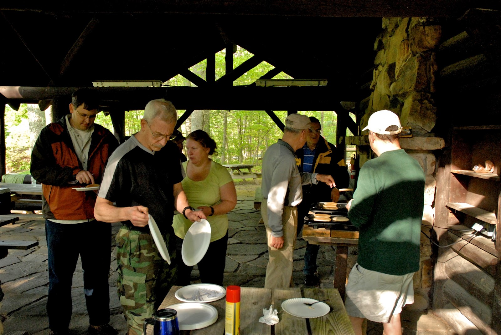
After camping out at Sherando Friday night, tormented by a lovesick whippoorwill, we awoke to cloudy skies threatening rain. Here we are having breakfast before the recon survey…

As we were cleaning up from breakfast, we got the low-down on the maintenance work weekend details from Ranger Kelly.

I was assigned to hike the Mau Har trail with Mark, Dottie, and Michael. We entered the Mau Har trail at the Maupin Fields Shelter.

As we walked along, Mark took notes on all the downed trees that needed to be taken down, all the water diversion structures that needed to be built, and the tools that would be needed for the work weekend coming up.

We hiked as we traded stories, and admired the beautiful surroundings. A light rain began to fall so we donned rain gear, but it was pleasant going. As we went, we admired the work that had been done by TATC volunteers that had come before us. This notch cut in a slippery rock face made the trail passable – a tribute to Bill Rogers.

I learned a new trail term on this trip – a PUD. This picture was taken on one of the few PUDs on the Mau Har trail – Pointless Up and Downs!

The rain was filling the creeks along the trail, and it was great to see all the little waterfalls along the way. The fly fisherman in me kept wishing I had brought my rod so I could see if I could coax a native brook trout from the many plunge pools we saw.


There were also lots of cool rock structures to see on the Mau Har Trail. This one had water seeping over it so it was covered with a carpet of luxurious moss.

Along the trail, there were flowers everywhere. Dottie kept a photo log of what we saw. There was mountain laurel, rhododendron, and the beautiful azaleas. 
We completed somewhere between 5 and 6 miles of trail recon and then made our way back to base camp at Sherando Lake. As the other volunteers returned we heard all the stories of downed trees and, unfortunately, trash that was defiling the St. Mary’s Wilderness area.
Marcus entertained us with bird calls on his e-reader. We talked story as we fired up our camp stoves, reconstituted dehydrated foods of various kinds, and ate dinner. We stayed up until the trail miles hung heavy on our eye lids and we tucked into sleeping bags for the night.
We arose the next morning with great anticipation as Mark and Scott treated all the volunteers to a celebration meal of pancakes, bacon, and sausage patties and links! In the TATC – you eat!
It was a great weekend – with friends – spent in service of TATC and our fellow backpackers.
(white) blaze on my friends!
Kevin
JC put together a backpacking trip for a group of friends so JC, John, Jonathon, and I joined Bryan and Ike from Richmond for a weekend on a Shenandoah portion of the AT up near Sperryville VA.

We left Hampton Roads around 1 pm on Friday (10/19) and rendezvoused with Ike and Bryan in Short Pump before grabbing some grub at Jimmy Johns and hitting the road west. We entered the Shenandoah National Park at Thornton Gap, JC got our backcountry permit, and then we staged a truck at the Panorama area and then drove everyone to the parking area for the Rock Spring Hut (blue mark on the map above) and hiked in the dark for about seven tenths of a mile to the shelter (the first area highlighted in yellow above).
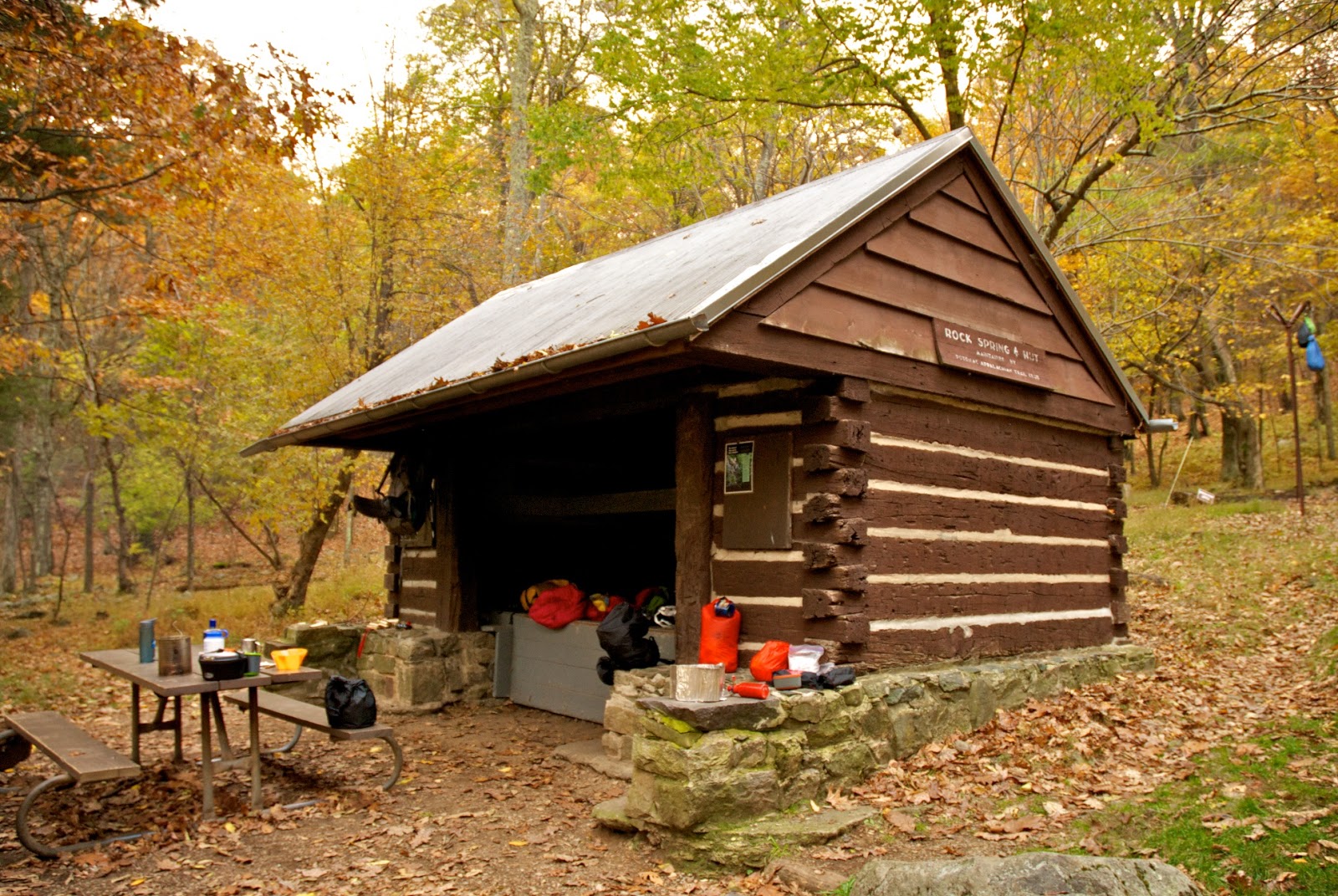
There were two guys already in the shelter, and we enjoyed the fire and the conversation, and the apple jack, until it was time to hit the hay.
JC and I chose a tent site up on the hill above the shelter. It was not that flat…

For those of you that care about these things, here’s the privy…

First thing in the morning, we engaged in that time worn ritual – pumping water for making breakfast and carrying during the day’s hike. Here’s JC and Ike gettin-er-dun!

After oatmeal and some coffee, we got our stuff together and made our way back to the Appalachian Trial and turned out sights north towards our next shelter at Byrd’s Nest #3.
After about a mile of hiking, we reached the first of two rock slides. John monkeyed around on the rocks while the rest of us picked our way through the ankle-twisting minefield.

The views from the rock slides were very nice – our first open views of the magnificent fall colors in the Shenandoahs!

John was doing a project for college – taking GPS coordinates on points of interest along the trial and making notes. When he wasn’t be studious, he was climbing rocks and playing where’s Waldo.

Our first major way station was Skyland. On the way, the trail was pleasant and picturesque.

In several places, the AT comes close to Skyline Drive which takes away the sense of wilderness we crave. Oh well…. Some descents, some ascents and we soldiered on.
While wildlife was sparse along the trial, we did get to see this growth on an old tree that looked like a female lion.
While wildlife was sparse along the trial, we did get to see this growth on an old tree that looked like a female lion.

At about mile 2.6, we got another nice view of valley to the west. Here are a series of photos looking northwest, west, and southwest from that vantage point (Timber Hollow I think).
At about mile 2.6, we got another nice view of valley to the west. Here are a series of photos looking northwest, west, and southwest from that vantage point (Timber Hollow I think).


Purdy nice!
At mile 3.8, we made it to Skyland – a resort that was built before Shenandoah National Park was dedicated. We sloughed off the packs and enjoyed the view, but the west wind buffeted us and it was cold. As we donned extra layers, John bought a round of hot apple cider for the crew to enjoy. Damn Good! We ate some lunch for fuel and I think provided some comic relief for many of the well heeled tourists leaf peeping on Skyline Drive.

Here’s the view from the patio between the Skyland restaurant and the office.

Leaving Skyland, we skirted along the east side of Stony Man Mountain and crossed the highest point in the National Park at 3,837 feet. We decided not to climb Stony Man since it was past 1 pm and we had another 6 miles to go to make the Byrd’s Nest #3 shelter. Our next major landmark was the Little Stony Man cliffs and we did stop there briefly to enjoy the views. Here’s (R to L) Jonathan, Ike, and JC)

Here’s the view from Little Stony Man. (Stony Man Mountain is in the upper left-hand corner of the picture.)

JC on Little Stony Man with the view looking NW.
We continued on as the AT paralleled Skyland Drive. I have to admit, I do not like hearing cars from Skyline Drive while I’m on the AT. I also do not like having to share the trail with the hoards of tourists from the overlook parking areas, but I do understand the desire to see the sights. I’m thankful for the portions of the AT and other trails that provide solitude for those willing to make the effort. Ah, but I digress….
Onward to the Pinnacles…

The colors on the mountain slopes were gorgeous and every opening in the canopy provided excellent views. However, there was lots of color all along the trail. You just have to remember to lift your head up!

After about 4 miles from Skyland, we reached the Pinnacles picnic area. We hustled through the hoards and continued on the AT ascending about 400 feet over the next 1.4 miles before being rewarded with this fantastic view of Jewell Hollow.

The highest point of the Pinnacle is at 3,730 feet. The trail descended for 0.8 miles until it delivered us to the Byrd’s Nest #3 shelter (second area highlighted in yellow in the map below).

The shelter at Byrd’s Nest 3

We had heard about a fireplace in the shelter and we discussed forgoing the tents for the luxury of a fire-warmed shelter spot. Unfortunately, when we turned the corner to see the front of the shelter, this is what we found!

Some “City Folk” from northern VA had thought it was a good idea to actually pitch their tents inside the shelter – makin it unusable by anyone else. You’ve heard of trail names, trail magic, trail angels… this was TRAIL HERESY! And when we showed up, they seemed oblivious to their greedy and wasteful ways.
We just set up in the tent camping area behind the shelter to avoid any conflict. Turns out that was good Karma since the tent area was sheltered from the cold west wind and, consequently, our camping area was about 10 degrees warmer than the shelter area.
Note to cabin hoggers, the sun doesn’t set and rise on the same side of the mountain! Our good Karma continued as we woke to this.

We made a quick breakfast and broke camp as quickly as we could. Here’s JC, Ike, Bryan, and John.

John and Bryan were kind enough to hike the extra 0.3 miles to the spring to pump water so we’d all have enough for the hike out . I think we solved at least 2 world problems during the short wait.

Up we climbed for about 0.4 miles to reach this fine view.


Jonathan again with the classic silhouette.

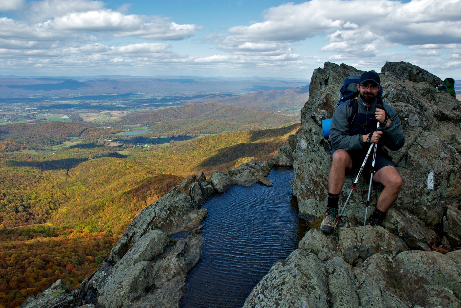
After about a mile, we made it to the spur trail for Mary’s Rock. Speedsters Ike and Bryan were coming down the trail as the rest of us made our way up and they remarked that the views from Mary’s Rock provided the “reason we do this”. I couldn’t agree more and I think these were the best views of the trip.


Jonathan again – our sure-footed man on the mountain!
As we scrambled up to the top of Mary’s Rock, we found these geodetic markers (3,514′). One old…

And one new…

Geologists believe Mary’s Rock is over one billion years old!
The view from the peak was even more beautiful!
Looking south…

The VA Piedmont to the east…
|
|
|
|

It was so nice, and the hike back to the car was a scant 3 miles, we took our time poking all around Mary’s Rock. Here’s John getting comfortable.

The AT skyline and the Alleghenies to the west…

Jonathan being pensive at the top of the world…

Coming down the trail from Mary’s Rock were were pumped (especially John)!

From Mary’s Rock, the trail descended steadily for about 1.7 miles to the Panorama parking area (second blue highlighted area in the map profile below).

In that time, we solved another world problem or two as our calves began to talk to us. Enjoying the high of a great trip with great friends, we ignored the burn and cruised to the truck waiting at the Panorama parking area where we celebrated with a group shot.

We threw packs and JC and John into the back of the truck and shuttled back to the Hampton Roads vehicle for the ride home.

We drove about an hour through the beautiful VA countryside before arriving at the Barbecue Exchange restaurant in Gordonsville. I think Ike calculated that he’d lost about 6,500 calories just on Saturday’s hike alone. After barbecue, slaw, beer, hush puppies, fries, sides of ribs, pie, and assorted other vittles, I think we erased any weight losses, but, hell we earned it!
What a great trip! On the ride home, we eagerly talked of our next trip, maybe picking up where we left off and doing another section hike of the AT. We’re so lucky to live in VA and within striking distance of the Shenandoah National Park.
Peace!
After getting snowed out in June 2010, I returned to Yosemite in 2011 with my friend JC to hike the John Muir Trail (Tuolumne Meadows to the Devil’s Postpile National Monument). We planned to spend a few days doing practice hikes, staging the rental car at the end of the trail, and getting acclimated to the altitude, and then spending a day at the end taking in the Pacific Ocean. This is the story o our adventure….
Saturday, August 6, 2011 Norfolk to San Francisco
Get to the airport for the afternoon flight. Fly from Norfolk to Las Vegas, Lost Wages to San Diego, and San Diego to San Francisco. Bunch of drunks on the plane from Vegas to San Diego. Took the opportunity to finish Ecology of a Cracker Childhood and started Gods and Generals. Flight was long, ate crap food to save money, but the flight attendants on Southwest were generous with the snacks and drinks, and with the humor.
Happy to get in at San Francisco even though the flight arrived late. Caught the shuttle to the hotel, Millwood Inn, and hit the hay.
Sunday, August 7, 2011: San Francisco to Yosemite National Park
Got up early, showered, checked email and sent messages on the hotel computer, and got my free breakfast on. JC had mapped out the travel path to get to Rent-a-Wreck (RAW) from out hotel. We caught the bus to the Bart, took another bus to within about 3 blocks of RAW and hoofed it there by about 9:15 am.
Picked up our sporty Kia Rio and, with the assist of JC’s smartphone GPS app, made our way back to the hotel in no time flat. Picked up all our luggage and camping gear and hit the road. Made one pitstop to the closest REI store only to find they were having their end of the season clearance sale = MOBBED! At least the mob was outside. We went int he store and got our MSR Superfuel and JC picked up a pair of sturdy trekking poles.
Now we were on our way to Yosemite for real. The driving was easy and we made a few stops to take some pictures, buy almonds, eat some lunch, and enjoyed the ride. We made it to the gates of Yosemite in about 5 hours – right on time. Normally, the entrance fee is $20 and it’s good for 7 days. As luck would have it, our itinerary would have us re-entering the park after 8 days and we risked having to pay the entrance fee twice. After explaining our predicament, seeing our backpacks in the back seat, noticing the sheer economy of our ride, the uber-cool Park Service guy let us slide on the entrance fee. Sweet!
We get our camp site at Crane Flat (#222) – very nice.

Good site and it backs up to a beautiful meadow.

We set up two tents to delay the impending backcountry 2-man tent “bro-mance” (as my wife likes to say while chuckling!). Then we head down into the valley to get JC some face time with the granite. The Valley does not disappoint. As the sun starts to fade, the Range of Light blossoms in all its glory. I cannot resist taking more pictures of the landmarks – El Cap, Half Dome, The Three Sisters, ++++++++ We have a beer from he Curry Village store before heading back to the campsite for some dinner in the dark.
The Valley as the sun sets…

Monday, August 8, 2011: Yosemite National Park
Up at 6 am and get busy making breakfast – oatmeal and coffee. Clean up, get water, messed around a little, and left by 7:30 to head down into the Valley. We planned to hike the Panorama Trail down from Glacier Point to get some altitude in our lungs and miles on out shoes. Just daypacks on this hike.
Drove to the Yosemite Lodge to pick up the Glacier Point Tours (209-372-4386) bus tickets to ride up to Glacier Point. Caught the bus at 8:30 am. Jack, our driver, was great and full of facts and stories to entertain us as we climbed the road to Glacier Point. Jack told us about the “Avalanche” fire that was burning in the park and was being watched but allowed to burn to provide all the natural burn benefits to the forest ecology. At times were were surrounded by the thick heavy smoke and it lingered int he valley and up in the high peaks, depending on the wind direction, for part of each day were were around the Yosemite Valley. On the way up to Glacier Point, we saw two of the three wildlife stars of Yosemite (mule deer, coyote, black bear). First we saw mule deer which were common on our trip. Then we saw a black bear mother and her two cubs. It’s hard to not get excited at seeing bears!
Got to Glacier Point, showed JC the sights, hit the loo, and then started the Panorama Trail. Took lots of pictures of Half Dome as we hiked to Illoette Falls.
Half Dome from the Glacier Point Geology Cabin

JC doing his best North Face imitation…

Upper and Lower Yosemite Falls as seen from from Glacier Point

The start of the Panorama Trail


More Half Dome…

About only a mile down, we ran into a guy who had rolled his ankle and was headed back up to see if he could cajole the bus driver into carrying him back down to the Valley. Talk about getting spooked! I was being careful not to end out adventure before it started.
Looking at the back side of Half Dome as we hike along…

Illilouette Falls was pretty and flowing good! Here it is with the back side of Half Dome in the background.

Old sterioscopic view of Illilouette Falls…

We stopped for lunch upstream of the falls and took our time to soak in the forest gestalt before continuing on to Nevada Falls.
JC pumping water…

The stream above Illilouette Falls where we had lunch…

The oft ignored sign warning unwary adventurers that the falls present a danger…

The cascade leading to the placid pool before the stream disappears over the edge of Illilouette Falls….

Along the way, we see lots of squirrels and chipmunks, and some funky grouse – mother and chick.

The trail continued to provide stunning views of the backside of Half Dome and Liberty Cap (featured here)

A unique handcrafted water control structure along the trail…

Views of the forest on the way to Nevada Falls…


Nevada Falls was big, raging, and crowded. There were people all over resting, soaking their feet (we did too), pumping water, and generally hanging out in the stream and pool above the falls.
The stream leading to the brink of Nevada Falls…

Nevada Falls with a veil of smoke from the Avalanche Fire…

The way down from Nevada Falls was a steep, sheer, set of stairs. It was slow, crowded, and hard going. But it did provide spectacular views of Nevada Falls from below. See for yourself!

The cascades below Nevada Falls….

Once the grade started to level out, we stopped at Silver chute, then Emerald Pool, and then to Vernal Falls. Incredibly, with the over-the-falls deaths of 3 scofflaws a couple weeks prior, there were still people beyond the warning signs and in the pool above the falls. Darwin at work!!!!!
Took some snaps of Vernal and then made our way down more steep steps to get down. Having hiked the Mist trail twice now, I don’t have any desire to ever do that again! I’m over those crowded steep steps! Once we were at the bottom of the trail in Happy Isles, JC called his wife and I went to the Mountaineering Shop in Curry Village to look around. JC meets up with me and we get beers and chips and hang our on the porch before driving home for some Mountain House meals and bed.
Sunset over the valley…


Tuesday, August 9, 2011: Yosemite (Tuolumne Meadows) to Mammoth
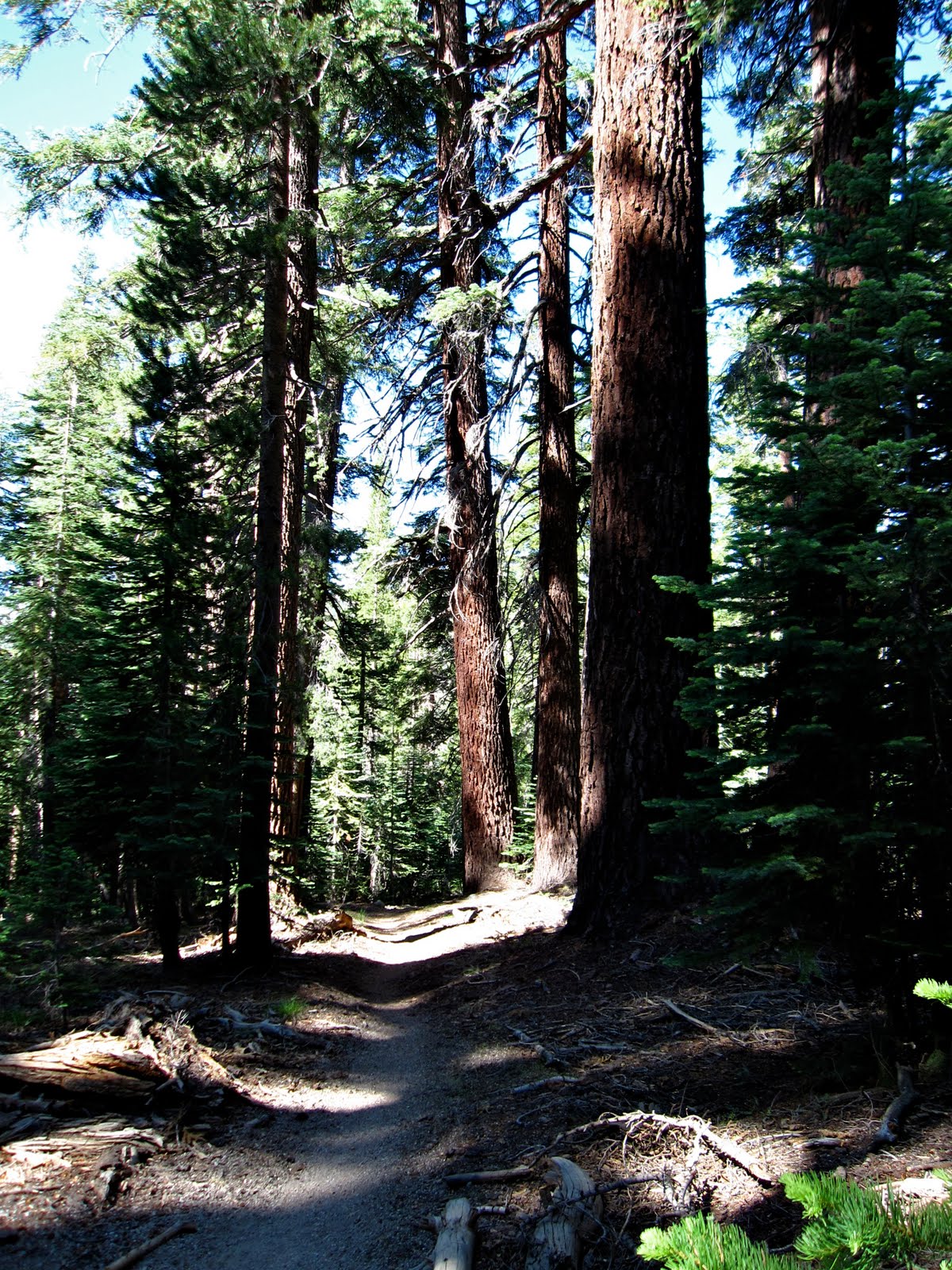
Got up early – 6 am – and had just a Clif bar and coffee (anticipating a big breakfast at the White Wolf Lodge. JC wanted to see some Sequoias while in Yosemite, but we didn’t have time to commit to go all the way to the Mariposa Grove so we checked out the Tuolumne Grove instead. It was a mile downhill to get to s small grove of trees arranged along a short loop. If you wanted to see sequoias and check the box, you could do it here, but it was poor in comparison to Mariposa. If you really want to see the BIG trees, make the time to go to the Mariposa Grove.
JC checking out the Sequoia’s core…

We (I) huff and puff the mile uphill and make it to the White Wolf Lodge at 10:30, only to find that they stop serving breakfast at 10 am. Damn! We drive on to the Tuolumne Meadows with stops at Olmstead Point and Tenaya Lake for pictures. We tried to pick up our backcountry permit a day early, but got shut down.
Tenaya Lake…


Rocks? Oh, I see one!

We hiked to Soda Springs (naturally carbonated mineral water) and the Parsons Lodge. The Lodge was built in 1915 from local granite and was originally a meeting room for the Sierra Club. We then continued on towards Mono Lake and Mammoth.
Soda Springs…

Cathedral peak with the Tuolumne River in the foreground…

On the way out of Yosemite, you’re supposed to show your entry fee receipt (to catch anyone who snuck in at night and didn’t pay). That ranger who let us in for free probably knew we’d get tagged on the back end and all the while we thought he was cool. Once at the booth, we just acted stupid, rummaged around for our immaginary receipt and then the ranger asked us how much we paid at the entrance. We knew the answer to that question, 20 bucks, and she let us pass.
Once out of the National Park, we passed some nice and some sketchy campsites before winding our way through Tioga Pass. We pulled the Kia to the right on all the climbs and let others pass as she struggled to make the grade. Don’t hate the Koreans, she was a good little, fuel-efficient girl!
Tioga Lake…

Tioga Pass…

We came upon Mono Lake and made a diversion to see the Tufas (mineral formations exposed in the lake due to a draw-down of water by the City of Los Angles). At one of the overlooks, we spotted this cool cat with an Area 57 sticker on his VW camper. Off the grid?

We made a stop at the Mono Basin Visitor Center in Lee Vining and got directions to the must-see South Tufa formations.

Mono Lake was dry, barren looking, and JC said it looked lifeless. Except of course for the 10 gazillion little black flies that rimmed the lake shore. Thank god they didn’t attack or bite! We got some pictures of the Tufi (plural?) and then continued on our quest.
Tufi…


Remembering my Tidewater Appalachian Trail Club roots, we stopped at the Mono Cone for some ice cream.

Tooled into Mammoth and stopped at the Mammoth Visitor Center (worth a stop), picked up a Centennial Devil’s Postpile pin, and then headed on to Shady Oaks campground. After checking in, we took the drive up to the Mammoth Ski Lodge to recon where we would stage the car and pick up the YARTS (Yosemite Area Rapid Transit) bus back to Tuolumne. Got that squared away, and then headed back down into town for some pizza, beer, and last minute map checks and camera battery charging at Joh’s Pizza using their wall outlet. That’s one thing that sucks about Yosemite campgrounds – unlike Yellowstone, the Smokies, or others I’ve been to, the bathrooms don’t have power outlets to recharge camera batteries so you got to carry extras and get creative with recharging. I think I’m going to get a solar powered charger so I don’t have to worry about this in the future.
Back to Shady Oaks, for a pack shakedwon. We set up the tent, I retrieve my other (Nikon) battery charger from the camp host’s RV outlet, hit the head, and go to bed.
Wednesday, August 10, 2011: Mammoth Lakes back to Tuolumne Meadows (Yosemite NP)
Got up at 5:45, broke camp, reloaded the pack with everything I would need for the JMT, and headed into Mammoth Lakes to get coffee and a muffin before heading on to the Mammoth Mountain Inn to pick up the YARTS bus back to Tuolumne Meadows.
JC and our pre-packed “yard sales”…

Parked the car and hopped on the bus with two other backpackers. I hung out at the Tuolumne Campground Office while JC went to get the Backcountry permit. Once secured, we walked back into the campgrounds and found the back loop where the backpackers campground was located. We paid our $5 per person at the self-serve kiosk and set up the Big Agnes 2-person tent. With time on our hands, we headed to the camp store. I got a Pepsi (no Coke!) to try to soothe the raging headache I had. (I assumed the headache was from caffine withdrawl, but would later find this was a symptom of my worsening altitude sickness)
The Pepsi gave no relief, but we decided to hike ~4 miles RT to Dog Lake (from the Glen Alum Trailhead) to get more miles and altitude under out belts. We also wanted to see how bad the mosquitos were – since it was a big topic of conversation at the backcountry permit office.
On the way to Dog Lake (520’ up), I stopped to fish in the Tuolumne River. I got hits on the hopper pattern I had left over from a previous trip to Yellowstone, but I lost it somehow due to a hastily tied knot. My bad. I tried a stimulator in the same seam and at a few other places, but it garnered no interest. I think it was too big!

On to Dog Lake. We hiked through the Tuolumne meadows, saw herds of mule deer and stalking tourists, trout in the streams, a bear cub by the road, a snake and a marmot among the rocks. When we got to Dog Lake (9,170’), we found that it was very beautiful, but there were lots of mosquitos that would attack as soon as you stopped walking. After a liberal application of DEET, JC and I hiked to the far end of the lake looking for the inlet stream. We found a broad meadow a little channel cut in the peet that we guessed was the inlet. Very beautiful place with lots of lovely flowers surrounding the lake. Well worth the hike.
Dog Lake (One of my favorite images from the trip)

Dog Lake, shoreline flowers…

After the hike down, I check out a hotspot and find a nice big blister on the side of my big toe. After some mandatory liquid sedation of the operating attendent, JC lanced the blister, cleaned it and applied moleskin and taped it in place. Feels good. We ate dinner and had lots of conversations with our camp mates. My head was still aching when I went to bed.
Thursday, August 11, 2011 Tuolumne Meadows to the Lyell Fork Bridge
We got up at 6 am, gave away our extra food, and were out of camp by 8:00 am. We messed around a bit, taking pictures of mule deer in the morning mist (elevation ~ 8585′).
Mule deer in the shadow of Lembert Dome (a roche moutonee – formed by a glacier flowing up and over the granite top.)

Finally connected with the JMT by about 9:00 am.

The hike eastward up Lyell Canyon was filled with gorgeous scenery! If you lived close by and could get a wilderness permit. this would be a great place to set up a base amp and hang our for a couple days dayhiking and trout fishing! As we passed, the prairie dogs chirped at us to warn their kin and we saw marmots scurry among the rocks.

The beautiful Lyell Fork of the Tuolumne River…


At 11:30, we passed the avalanche rock slide that marked the halfway point or day’s hike and the place where you can legally start camping along the trail. We stopped and had lunch and I fished a bit.


Caught one brookie on a royal coachman “X” pattern.

There were spectacular views of the Lyell Fork of the Tuolumne River and the canyon on either side.


We made it to the head of the canyon by 1:30-2:00 pm (9000′) and began the 1 mile climb up ~ 700 feet in elevation. For me, the hike up was brutal! I was stopping every 100 paces to rest and catch my breath. My headache had not abated and I did not know, but my altitude sickness was about to add nausea to it’s little bag of torments.
Here, Bruce from Scotland powers past us…

Trail maintenance….

JC and I made it to the Lyell Forks Bridge (9650′) at around 3:30 pm. I was exhausted, but we set up the tent and napped as mosquitos hovered looking for a way into the mesh. Got up around 5:30, washed sweat-soaked clothes, gathered firewood, and made dinner. On top of the headaches that had accompanied me up the trail, I now was nauseous too. A cup of tea (caffine) did not help with the headaches (I did not recognize the common symptoms of altitude sickness). After dinner, I made a big fire and burned the food I couldn’t bear to eat. We got the bear canisters set up, but started to worry what to do with the packs since the Lyell Forks Bridge campsite is notorious for bear raids. In the end, we left them outside, but a little ways from the tent. The mosquitos tapered off after sunset, There was a nice big moon. It didn’t take long for the roar of the river rushing in the gorge below us to put us to sleep.
Friday, August 12, 2011 Lyell Forks Bridge to Thousand Island Lake
Got up at 6 am and pumped water for breakfast. I was still feeling sick to my stomach and could only eat 1/4 of my oatmeal and take a few sips of coffee. We broke camp and hit the trail at 8:30 to begin the climb to Donahue Pass. On the way up, we encounter pockets of snow. Aside from the nausea, it feels good to be high up and in the snow zone.
In the snow zone…

We climbed about 500′ in elevation to a small lake surrounded by a meadow. It was great to see snow in the mountains, but the pass was out of view and the added elevation was daunting.

There was a red tinge to the snow and we were trying to figure out what that was from. My best guess was that the pollen from the surrounding pines was tainting the white snow (like the yellow pollen that covers everything back home in VA).
Here’s a picture of a possible culprit…

A view of the lake from above…

We rock hopped across the lake outlet and continued to climb along a narrow trial and crossed a bunch of snow-melt streams and we went. Every now and then we had to cross a patch of snow and we were careful not to slip and were hoping not to punch a hole through a gap in the rocks underneath. We encountered another lake and again had to rock hop across the outlet. I wedged a trekking pole between two rocks and when it didn’t release, I got thrown off balance and had to take a big dunking step in the water to keep from going all in. I rallied and got to the other side. We took a break so that I could change socks and I’m very glad we did.
Here’s the lake that almost dunked me with more red-tinged snow….

Up we climb, with spectacular views all around.
Flowers flanked both sides of the trail…

Engineered steps led the way…

Crystal clear puddles were an amazement…

I was slow going as we picked our way up the grade. There were tricky rock sections interspersed with snow patches, but finally the pass came into view. We had a long stretch of snow to traverse as we climbed and so we followed the path of those who came before us. I know seeing the top of the pass buoyed my spirits. JC said the views made him want to yell “Ricola”.
Snow field traverse….


Reaching for the top of Donahue Pass…

We had our lunch at Donahue Pass (11,056′) which is the Yosemite border. A marmot chirped at us, the intruders, as we enjoyed the view. Before long, we began to pick our way down and into the Ansel Adams Wilderness (formerly Minarets Wilderness) and the Inyo National Forest. As we wove our way down the switchbacks, the scenery was filled with glacial erratics – boulders dumped by one of the glaciers.
Looking down into the Rush Creek drainage from Donahue Pass…

The Rush Creek drainage (9,640’) at the base of Donahue Pass was very pretty, but also full of mosquitos so the bug nets came out and we raised and unfurled them as the need arose. Rush Creek drains to Mono Lake, the end of the line since Mono has no outlet.


he quiet stretches of Rush Creek looked like this…

Everywhere you turned, the scenery was spectacular! Here we are looking at Koip Crest to the north…

Among the mountains, snow, and clouds! Banner Peak points the way to the heavens…

JC crossing the Rush Creek log bridge at 10,040′ near the junction of the Marie Lakes Trail…

Rush Creek picking up speed as the elevation drops…

We made it to the base of Island Pass by 3 pm, pumped water, and had a snack to fuel up for the 600’ climb.

The pitch to Island Pass was not as steep as Donahue and there were good switchbacks, but I became exhausted nevertheless. The nausea and lack of food in my stomach were taking their toll but we continued on – taking comfort in all the beautiful scenery.
A fallen tree on the way to Island Pass. Koip Crest in the background….

The twisted remains – nearly as beautiful in decay as in life…

The top of Island Pass (10,205’) and the surrounding plateau of land was gorgeous – one of the prettiest sights on the hike. In retrospect, if we could have extended our trip and planned to camp at Island Pass, we would’ve.


The way down from Island Pass was full of little crystal clear ponds and panoramas filled with the looming Banner Peak. Since we were on the west side of the crest, all the water we would see for the rest of the trip would drain into the San Joaquin River and eventually flow into San Francisco Bay. The backdrop on our horizon was now the Ritter Range with Banner Peak most prominent.
I was thankful when we made our way 1.8 miles down to Thousand Island Lake (9,833’).

Unfortunately, it was a big pain to try to find a campsite meeting the rules (not on vegetation) as the rocky perches away from the lake or feeder streams were few and far between. I was exhausted so JC did all of the work hunting for a site and he finally found a spot to share with Bruce from Scotland – a guy who passed us on the way up to Donahue Pass. Bruce was on the trail to do the full JMT, but was suffering from altitude sickness like me and he was saying if it did not clear up in a day or two he was going to abandon his attempt. I could totally understand. You can’t do that trip without eating to refuel the furnace!
We made dinner, and, once again I could only eat about half of my raimin, We cleaned up our bowls. To keep my mind busy, I fished for a while and lost a fish on the retrieve. Probably not a good hookset on the little guy. There were lots of “gulpers” taking tiny little black gnats – size 20 or 22 – a fly I did not have.
Took some sunset pictures and went to bed. I hate to say it, but I was thinking: half done.
Electric sunset at Thousand Island Lake with Banner Peak front and center!


Saturday, August 13, 2011 Thousand Island Lake (TIL) to Rosalie Lake
Woke up early and pumped water. Fished a little and took pictures while JC slept. Hooked another small fish on a size 16 Henryville Special (smallest fly I had), but lost him.
Sunrise with rising trout disturbing the mirror effect of Thousand Island Lake…

There seemed to be a lot of non-backpackers at TIL. There were lots of base-camp type set ups, tons of people fishing the lake, dogs, etc. Seemed obvious we were not in the National Park and it did not feel much like backcountry. We would have much preferred to stay someplace more remote like Island Pass or pressed on to one of the other lakes if I had the stamina.
Boiled water for breakfast, but 1/2 of a Clif bar is all I could get down. Didn’t fight the sickness at this point, just went with the flow. We broke camp, used the head, and got on the trail a little late. It was 9:45 when we rolled out of TIL.
On our way again…

We had to hike up and out of TIL and then down again to make the 2.6 miles to Garnet Lake (9,678’). It seemed to take longer than it should’ve. That’s probably just me feeling weak. Poor JC having to put up with my crap!
Ruby Lake was clear, beautiful, and trouty…

Garnet Lake looked like a repeat of Thousand Island Lake…

Crossing the outlet of Garnet Lake and continuing on….

After another 2.5 miles, we have lunch at Shadow Creek (9,000’) where I force down the second 1/2 of my Clif bar. We continue another 0.9 miles down to Shadow Lake (8,737’) and then turn southeast to start the last steep climb of the trip (yeah!). Take it slow, again about 100 paces at a time.
Flowering shrubs and ground covers are our reward for making it to the top of the pitch…

The landscape is filled with talus…

On the descent we pass a guide and his client on horseback heading to Garnet Lake for some fishing…

We descend 1,100 feet past a small meadow and through a tiny canyon with lodgepole pines and mountain hemlock cover. Anywhere we find water, flowers abound.

At 9,000′ we came to a trail junction – right went to Ediza Lake – but we continued on to the left towards Shadow Lake. Along the way, we paralleled and crossed Shadow Creek.
Amazing crystal clear water with to-the-bottom visibility and interesting fringing wetlands…


Shadow Creek becomes a torrent…

Shadow Lake…

After an hour and 15 minutes, we make it to Rosalie Lake. It lives up to its reputation. Gorgeous!

We find a nice camp site with a good fire pit nearby. We take pictures, set up the tent, wash clothes and chat with neighbors. During the conversation, we find out that the highly anticipated showers at Reds Meadow are our of service and will be for the entire year! WTF!!!!! That’s a stop I think that most backpackers covet! Our heads swim with alternative plans for a scrub. I am still planning for a stop to fill my belly with one of their famed milk shakes (down at lower altitude)!
After dumping the packs, setting up camp, and squaring away the bear canisters, we climb some rocks to see the sunset.
JC contemplating the meaning….

Looking towards Mammoth Mountain…

JC and I return to camp for a dinner of couscous and Kathi’s special spices – Yum! I eat as much as my stomach will allow. After dinner, JC stacks the bear canisters to see if they get knocked over by a bear.

We make a good campfire and I repeat my new ritual of burning uneaten food. We stare at the flames fro a while, spread out the coals in the pit, and then hit the hay.
Sunday, August 14, 2011: Rosalie Lake to Devil’s Postpile National Monument

I’m up first, and I check the clothesline to see if the clothes have dried overnight. Even though the temperature drops down into the 40s, the air is so dry the clothes are dry after being washed late the night before. I snap a few pictures of Rosalie Lake as the sun comes up and then go to get JC so we can get moving towards that end-of-the-trail milkshake at Red’s Meadow.
Gladys Lake with the pinnacle of the “Two Teats” in the background…

One of the many Trinity Lakes…..

We’re dropping down through the trees. The JMT guidebook says the soil in this region is volcanic, but it’s hard to tell the difference – it’s just all dusty. JC continues to be accosted by mosquitos but it’s not so bad for me – my stink must be off-putting! Once again, water is life. Where ever we cross a snow melt stream, we’re treated to flowers, flowers, flowers.

The trail down from Trinity Lakes…


It seems like we’re moving fast enough, but the trail miles yield slowly. We’re running into a bunch of folks heading in the other direction and we swap stories about mosquitos and altitude sickness. We drop down to Jonhston Lake and the surrounding meadows (8,120’) and enter the Devil’s Postpile National Monument.
As you cross the Middle Fork of the San Joaquin River into the Postpile, you are immediately greeted with a basaltic extrusion (derscribed as warped organ pipes)veering off to the right – cool!
The San Joaquin…

Extruded basalt marks the entrance to the Devil’s Postpile National Monument…

Instead of heading left to the Ranger Station, we continue on with full packs to take a look at the main postpile attraction – accordianlike columns of blue-grey basalt that formed 10,000 years ago when magma flowed through Mammoth Pass and fracturedd vertically. We also hike to the top of the formation to look at the hexagonal honeycombed extrusion patterns.
The Devil’s Postpile…

The hexagonal pattern of the extruded volcanic magma. I love to say that word like Dr. Evil from the Austin Powers movie – magma!


OK, I’m done climbing! We head to the ranger station and wait for the bus to Red’s Meadow Resort. We get a free ride to the Resort and meet up with two guys we met at the entrance to the Postpile. They met online and were hiking the whole JMT. At the Red’s Meadow grill, they struggled to get a double cheeseburger down while I opted to fill my belly with some comfort food – a big chocolate shake. It’s old school – in a big metal shake cannister, and topped with whip cream and chocolate sauce. Come to Papa! It was worth every penny of it’s exorbitant cost!
JC points to the finish line at Red’s Meadow Resort…

The resort store… backpacker prejudice???????

We hop back on the shuttle bus, and pay $7 this time, to make our way back to the Mammoth Mountain Inn. We are happy to find that the Kia has not been attacked by a bear or vandalized in any other way. We dump our stuff, grab our toiletries, and head back to the Mammoth Mountain Inn where we’ve been told we can pay for a shower. We’re directed through a maze of backdoors, parking garages, and service elevators (keeping us hidden from the true guests) to a bathroom with a single shower adjacent to the hot tubs and a small outdoor pool. JC and I get clean just before a long line forms.
Feeling refreshed, we go back to the funky coffee shop in Mammoth where JC gets a killer sandwich, but I hold off for a burger back at the Tuolumne Grill. We head back to Yosemite with a quick stop at the Mono Basin Visitor Center for gifts for my kids. The Kia climbs slowly through Tioga Pass and shortly enough we’re back in Yosemite and Tuolumne.
We pull up to the Tuolumne Grill to find it closed. Damn it! JC is making comments about his great sandwich as I gnosh on microwave mac and cheese and some chips and dip that JC gets as a snack. We drive up to backpackers campground with the car this time, unload our gear needed for the night, set up camp, and then go park the car in the Lembert’s Dome parking lot overnight. Walk back to the backpacker’s campground and enjoy a nice campfire program by one of the seasonal Rangers. The crowd shares impressions and what’s special about Yosemite. Good classic campfire experience!

We’re back in two tents again – the bro-mance is over!
Monday, August 15, 2011 Tuolumne Meadows to San Francisco
We get up, break camp, walk to get the Kia (no bear invasions), drive it back to the backpacker’s Camp and load up. We head to the wilderness permit office and donate our remaining Superfuel (half a can) to a very grateful park employee and score some extra Yosemite Wilderness stickers in the process. In the parking lot we meet a trio of NC belles and donate our two mosquito head nets to their cause. They are slightly red-eyed from an overnight drive and perhaps a little underprepared but stoked nonetheless.
We start the drive home with a leisurely stop at the White Wolf Lodge grill for an all-you-can-eat breakfast that erases most of the weight losses we may have managed on the trail.
White Wolf Lodge…

On the way back through Tuolumne, we are ever mindful of our speed as these signs remind us that…

Thankfully, this sign has not date scrawled across it. Putting a date on the sign means that a bear has been killed in a collision.
We stop at the store at Crane Flat for some Devil’s Postpile brew and a few more trinkets. I make a pitstop at a turnout outside Yosemite to collect a few massive sugar pine cones. We make another stop near Groveland so JC can pick up some tie dye for his Mom (we pass on the homemade elk jerky).

We stop for lunch in Oakdale (again JC gets the gourmet sandwich while opt for the dollar menu), and we make it back to San Francisco in the early afternoon. We touch base with my friends Tom and Leslie and make plans to meet for dinner in Chinatown. Next mission – get JC’s feet wet in the Pacific Ocean!
We get downtown, but get totally hosed on Market Street because we can’t make a left hand turn to head toward the ocean. Out attempts to drive through Golden Gate PArk are thwarted, but we do manage to catch a glimpse of Haight-Ashbury and skirt the northern edge of the park until we make it to Ocean Beach. JC gets his feet dipping box checked and we start heading south on Highway 1.
Pacific foot massage…

We make a quick stop at Fort Funston to see the cliffs and Pacific Ocean and are mesmerized by the hang gliding going on there. Beautiful!
The beautiful CA coast looking south from Fort Funston…

Looking north from Fort Funston…

JC enjoying the gliders…

We make our way back to the Millwood Inn in beautiful downtown Millbrae. Chaos ensues as we unpack everything and begin repacking for the flight home. We wash out fuel canisters, charge camera batteries and phones, repack flight essentials (Ipod, reading material, snacks, etc). We shower and put on our best (least stinky) old clothes and drive to the BART station to catch a train into SF to meet the Crabs in Chinatown. There is some “civil unrest” at one of the BART stations (protest about the jamming of cell phone signals so people couldn’t photograph alleged police brutality) so there are armed cops, dogs, and riot gear all over the place.
We make our way by foot to the China Gates and window shop as we go. We pick up a few more gifts and then meet up with Tom and Leslie. Greetings and hugs all around with loud banter we pick a restaurant – one that has dim sum for JC. We chose one at random and the food is excellent! We have a great time and Tome and Leslie give us a ride to the BART station. We make it back to the Millwood Inn and the repacking resumes. I stay up until 2 am doing work for Lynnhaven River Now until they kick me off the hotel computer. Bed!
Tuesday, August 16, 2011 Sand Francisco, CA to Norfolk, VA
We drive to Rent-A-Wreck, drop off the KIA (no harm no foul!), and get a ride from the RAW crew back to the BART station for a train ride to the airport. Catch the plane to Las Vegas, hang for a couple hours, and then make our way back to Norfolk. JC reads the Ecology of a Cracker Childhood book cover to cover while I knock off sections of Gods and Generals. We make it home after midnight. JC picks up a car dropped by his wife and my friend JD picks me up for the ride home.
Glad to me home, safe, and with another great adventure under my belt!
Getting ready to hike the John Muir Trail later this summer and wanted to do a shakedown weekender to make sure the gear was working well and ID any necessary repairs or other needs.
My friend Chis recommended an overnight hike up to McAfee Knob and said we wouldn’t regret it. We were joined by our friend Harry (who had backpacked with me in the Smokies last October) and Noel (a friend of Chris’ and an avid AT section backpacker).
Friday, April 29, 2011
We left after work on Friday and drove past Roanoke to the Dragon’s Tooth trailhead parking lot on Rt. 311. We got in around 11 pm and pitched the tent in a grassy spot off the stone parking area. Chris thought this would be a good place to camp since there’s a good bathroom available at the trailhead.
Saturday, April 30, 2011
We got up the next morning, swung by a mini mart for some not-so-good coffee and sweets, and made it to the parking lot where Rt. 311 crosses the AT.
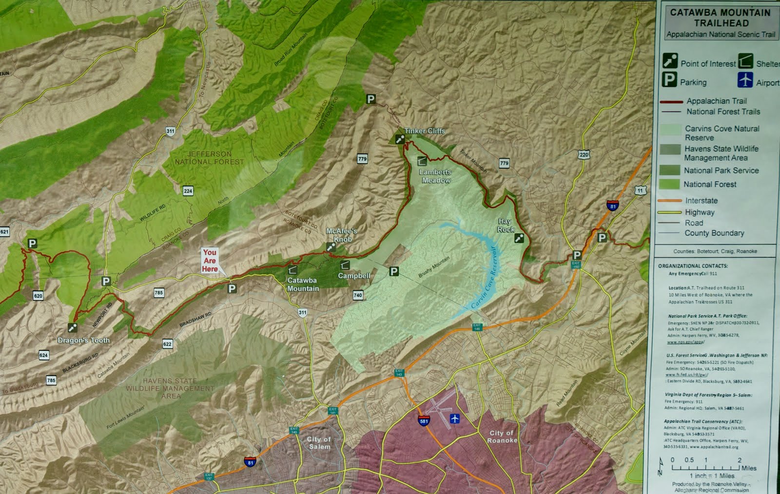
This was going to be the end of our hike, and it is also where we had out shuttle driver ( Homer Witcher: 540-266-4849) pick us up to take us to the starting trailhead – Andy Layne Trail. Homer charged the four of us $20 for the shuttle – a good deal! We got to the Andy Lane Trail about8:45 am and started our climb to the first destination – the Tinker Cliffs.

The hike started out easy with some fence and stream crossings before the trail started to climb.


It was steady going up, but not that difficult it seemed. We took breaks where we needed them and we were in no particular hurry so we just made our own pace.


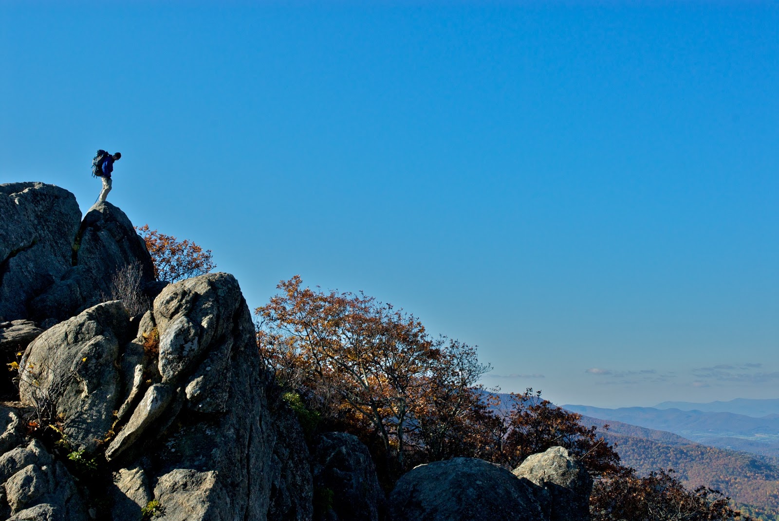
It was a beautiful day and perfect weather for hiking. You could tell as we approached the Tinker Cliffs, because these huge rock formations began to jut out of the ground.

The rock formations at Tinker Cliffs were spectacular as was the view!


At Tinker Cliffs we met a group of college students from Michigan who said they were taking their outdoor course final with a backpacking trip on the AT. Man, I wish they had those courses back when I was a student!. As we hiked away from the cliffs, we continued to enjoy the views, the flowers, and the rock formations jutting from the ground.


We were headed to the Campbell Shelter and had some more climbing to do.

More pretty flowers and rocks…


We made it to the Campbell Shelter by about 3 pm. and got the tents and hammock up, and we pumped water for the evening meal and to have a relaxing beverage. Harry always comes through with some specialty instants that he hocks during his international flights.

We lounged around, some more than others, as we greeted other hikers, and waited for our evening assault of McAfee Knob for the sunset views. Here’s a picture of a Nixon at rest.

Without packs, we bounded up the trail for about 3/4 of a mile to McAfee Knob. No wonder this is such a popular spot. The views are spectacular! If you click on the picture of Noel (below) it will enlarge, and you can see the Tinker Cliffs on the peak at the end of the ridge over his right shoulder.

Here’s a picture of Harry on the Knob

Momma don’t like this picture…

Even messing with the camera settings, I had a hard time capturing the sunset. Even as the sun went down, the sky was still bright and I just couldn’t capture the scene with my electrons. Hope my memory will serve me well.

Back at camp, we listened to some thru-hiker stories as we sat around the campfire. Sleep came easily.
Sunday May 1, 2011
We got up, made breakfast, and pumped water. We gave our extra food to the thru-hikers. I tried to offer a packet of instant hot cider, but one of the thru-hikers flipped the packet over and complained about the low caloric content and mumbled something about making it would be a waste of fuel. Apparently we messed around too much, because we were the last to leave Campbell Shelter.
We hiked up to McAffee Knob, with packs this time. The view was still great, but what it showed us was a rapidly approaching front – the rain was coming earlier than we planned.

We hoofed it down the trail to the parking lot where Rt. 311 crossed the AT. The rain was only intermittent and after about 1.5 miles we shed the rain gear. The trail was good and the hiking mostly easy with some ups, but not too bad.


Even with the rain in the forecast there were lots of day hikers headed for the Knob from the Rt 311 parking lot. We continued on and made it to the car without incident. Still raining on and off, we made it to Rt. 81 and pulled off for some post hiking grub. By the time we made it back to Virginia Beach, the sun was shining – another beautiful day to be alive!

Our friend Corky from Australia had been living with his family and working in the US for 3 years and was about to return home. But before he left, he wanted to see a bear in the wild. Taking him to the Great Smoky Mountains seemed to be a good bet for the sighting, so we picked a time when the leaves should be colorful (mid October), got the necessary backcountry permit reservations, and waited with anticipation! Our friend Harry would join us to make his first foray into the backpacking arena. Of course, we kept him in the dark as long as possible 🙂
Friday, October 15, 2010. Virginia Beach, VA to Hickory, NC
We left VA Beach at around 4:30 made it past Emporia and then grabbed Rt. 85 south. Missed the turn at Winston-Salem so had to jog north to get back on track. Stayed in Hickory, NC at a Best Western and, thanks to Corky, got a good government rate.
Saturday, October 16, 2010. Hickory, NC to Smokemont Campground in the Great Smoky Mountains.
Woke up at around 6:30, showered, and took full advantage of the free breakfast. Corky chatted up a women’s volleyball team heading to a tournament as Harry got the last opportunity for a late sleep.
Hit the road and got on the Blue Ridge Parkway at Jonas Gap to take advantage of the beautiful views of the mountains and maybe see a bear. Beautiful drive. Saw signs for Mt. Mitchell State Park and, since we had the time, pulled in to investigate. Parked and walked the last 100 meters to the summit of the highest peak east of the Mississippi (at 6684 ft.). Now that wasn’t so hard was it?
 Harry on top of Mt. Mitchell
 View from Mt. Mitchell
Had lunch at the park lodge and then continued on the Blue Ridge Parkway to the Great Smoky Mountains. We arrived at the Oconaluftee Visitor’s Center, filled out, and deposited our backcountry permit.

I convinced Harry and Corky to drive through Cherokee on to Sylva so that I could get my fishing permit. Lots of little towns with living mainstreets. Nice to see. Got the permit and a few small flies and winded our way back to the Smokemont campground.

Moonrise over the Smokies
We set up Harry’s tent in no time and then went back to Cherokee to Pauls for dinner. I opted to stay away from any camp food groups and had a fried fish sandwich and fries (that would be burned off in the trail miles to follow). Food was mediocre at best. Headed back to Smokemont in the dark and sleep came quickly.
Sunday, October 17, 2010. Smokemont Campground to Kephart Prong Trailhead to Sweat Heifer Trail to the Appalachian Trail to Icewater Spring Shelter.
Woke up as late as possible because it was freaking COLD! OMG we were freezin’ I ran to the bathroom and its heater was anemic! Got back to the tent and immediately searched out my gloves, wool hat and extra layers. Got water and commenced to boil and made everyone’s coffee. Corky and Harry got up and rushed off to the WC while I prepared breakfast. Pack-it Gourmet’s Bangers and Mash. The breakfast was fine, but I find their preparation too laborious and the smell of their sauces take weeks to leach out of my bowls. One still smells like Ya Ya Gumbo from last summer! I’m done with Pack-it Gourmet. We rushed to get the tent down and threw it in the back of the van. Cleaned up our backpack content “yardsales” making sure not to leave anything behind. It was so cold I packed an extra long sleeve shirt and long underwear (Note to self – both turned out to be unnecessary). Our AT shuttle driver arrived and we parked our car in one of the open spaces in the Smokemont campground since we were told that cars left for days at the trailhead on Rt. 441 were obvious and semi-routine targets for theft.
We rode the 3 miles to the Kephart Prong trailhead and took the traditional “before” hike snapshot.

We’re off! The trail was easy and we had fun crossing the Oconaluftee River on a series of foot bridges.


The beautiful Oconaluftee River watershed…

First stop at mile- 2 was the Kephart Prong shelter.

Just beyond the shelter we found the Sweat Heifer trail and up we climbed.

We took breaks along the climb and stopped for lunch at a beautiful cascade.

After lunch we continued to climb, break, climb, break, and so on. Saw a turkey on the trail. We made it to the junction with the AT at 3 pm – just steps from a beautiful overlook. We stopped at the junction and snacked and changed socks.


Only a little more up in the mile it took to get to the Icewater Shelter.

Icewater Spring Shelter

View from Icewater Spring Shelter
We were first to arrive at 3:45 and quickly claimed our sleeping spots on the top bunk. Others filtered in as we were pumping water. We made our Mountain House dinners at around 6 pm amid more arrivals. We checked the maps and chatted with our shelter-mates. Met a guy that designed the Arnold Palmer golf course in VA Beach. A group of six 20-somethings arrived and debated whether to stay (and sleep on the ground) or go (and hike about 5 hard miles up to the LaConte Shelter) since they didn’t have reservations at Icewater Spring. They went back and forth and finally decided to stay to the consternation of at least one or two. They settled down, made dinner and waited to see if they’d get a spot inside for the night. We all made room and I think the 14-person shelter slept 18 or 20 that night. One of the youngsters was an animator for Dreamworks who worked on How to Train Your Dragon. He had a killer camera and was showing us how to do some really cool time lapsed photography. One of the other youngsters had just come from Alaska and was on her way to be a ranger in Yosemite in the winter. Seemed like she had the perfect demeanor for the work. Nice girl.
We also saw this big fat grouse hop up in a tree and then work his way to the outer branches to feast on the tree’s berries. Cool!
The Icewwater Spring Shelter is a great place for the sunset/sunrise cause there are great views of the mountains and valley below with some nice trees to frame the view.

Icewater Spring Shelter: Sunset over the Great Smoky Mountains!
 Wish you were here?
We enjoyed the show and the company. I was ready for bed after sunset, but Corky and Harry made me stay up until 9 pm before going to bed. I barely made it.
Monday, October 18, 2010. Icewater Springs To Peck’s Corner Shelter
As good as the sunset was, the sunrise was even better. Great color and cool cloud patterns.
 Sunrise at the Icewater Spring Shelter

Ole reliable oatmeal for breakfast. Corky wasn’t eating because he was too busy chatting everyone up. That’s how he got his trail name… If not last, we were next to last to leave the shlter, but right before we left, we met a young couple with an Australian Blue Heeler pup. Corky melted. Picture-taking ensued. Then we met a couple from AL. More chatting. We finally got underway by 10:45 am. Tom, J.C., Will, help me please!
We headed for Peck’s Corner Shelter will lots of up and down planned for throughout the day.

On our way to the Peck’s Corner Shelter from Icewater Springs Shelter
About 2 miles down the trail we made it to Charlie’s Bunion. Everyone we talked to and everything I read said it was a must see. They were all right! Nice picture spot. There was a kid there who was just climbing down from the pinnacle and we were told he just lost his jacket. It and his daypack were tumbling off the cliff and he almost fell to his death lunging for his stuff and could only retrieve the pack. No way he could recover the jacket by hiking down. Bye bye…. We carefully took our pictures and left all our gear in safety against the trail and cliff wall.
 Charlie’s Bunion – people fall off and die every year!
 Corky on the tip of the Bunion
 Bunion on the left; Smokies as far as the eye can see…
 Vegetable and mineral at the Bunion
Back on the trail, we made our way to the Dry Sluice Gap junction (the alternate trial up from the Kephart Prong Shelter). Sign says 6.2 miles to Peck’s Corner. We past one set of south-bound thru hikers who had left Maine in June. We stopped for lunch and then worked through lots more up and down before we made it to the Hughes Ridge Trail that led to the Pecks Corner Shelter.


 Work on the trail

It was 0.4 miles downhill to the shelter (which meant 0.4 miles uphill for the start of tomorrow’s hike – crap) and on the way down we ran into some Park employees doing trail maintenance. Building runoff diversions – hard, muddy work! Said we appreciated their work, saluted, and kept on.

Made it to the shelter. My little MSR 11 oz white gas fuel bottle was making more meals than planned so we boiled water for an après-dinner coffee treat. Busted out the maps and discussed a shortcut that would shave a day off the hike and lead us directly back into the Smokemont campground. Harry rejected! He’s a trooper!
 Peck’s Corner Shelter
 Privy with a view
Trail book says TriCorner Knob Shelter is remote and smack dab in the middle of the Smokies. Who can resist “remote”? Yeah, we want to be deep in the Smokies and be as far away from roads as possible – only a piddling 7 miles at that point, but as far away as we could be. We want remote!
 Pumping Water; typical water source on our trip
Corky and Harry pump water and I hike down the ravine in search of trout. The guide book says a tributary of the Enloe stream flows from behind the shelter. At the water source, the “stream” is a trickle. I hike along the drainage to see if it opens up into anything bigger.
 Woods in the stream drainage
After about a half a mile of picking my way downstream, and keeping an eye peeled for bears, the trickle intersects with a bigger water course. At least I can hear it! It’s getting dark, so I tie my red bandana on a tree stretching across the stream at the intersection so I know how to get back up the right ravine if I’m coming back near dusk.

 The trickle begins to “widen”
After about another ½ mile downstream, I find a promising mini waterfall and plunge pool. Only about 8” deep, but broad enough I think and highly oxygenated.
 “da pool!”
Not a cast so much as a dangle and a fish rises to the offering. Not sure what it is, but it’s small. I place the #16 Henryville Special (one of my all-time favorite flies) at the base of the fall and the trout takes it with gusto. The gods favor me with a beautiful 6” GSM brookie. I’m in heaven!
 “GSM gift!”
That’s all I need to make my day complete! The brookie is quickly returned to his little wet world unharmed and I pick my way upstream as the light fades and my bear radar is on high. Water, fish food, a mile away from the shelter, this is where I’d be if I were a bear! Found my bandana without incident and made it the rest of the way back to the shelter before full dark. Noodles for dinner. We hang the packs up in the dark, and again stay up until 9 pm before being allowed to sleep.
Tuesday, October 19, 2010. Peck’s Corner to Tricorner Knob to Laurel Gap Shelter.
It was a beautiful sunny morning at Peck’s. We found out that two other guys in the shelter were also heading to Tricorner Knob. One left before us, the other after. It was a short hike of about 5.3 miles to TK, but with three climbs over Eagle Rock, Mt. Sequoyah and Mt. Chapman (the fourth highest peak in the GSM). We made good time up to Eagle Rock where we took a break for water and some snaps.
 Eagle Rock
 Elevation marker at Eagle Rock
Next up, Mt. Siqouyah, but we rolled over that peak. Day-3 climbing was still hard, but rest-recovery was much quicker.
 On our way to Mt. Chapman in the more “remote” sections of the Great Smoky Mountains
Hiking up Mt. Chapman was tougher. On the slopes, we caught up with the guy who left before us and we leap-frogged at rest points. We ate lunch at the top of Mt. Chapman and made quick work of the downhill to the TK shelter. Arrived at 1 pm after about 2.5 hours of hiking.
 We’re here!
 Tricorner Knob Shelter
 TK water source
It was a very nice shelter – one of the nicest on our trip. Since we arrived so early, as we took off the packs and surveyed the area, Corky hatched a plan to continue on for the next 6 flat miles to get to the Laurel Gap Shelter. There was a high probability that it would rain the next day and he reasoned that it would be better to hike the 5 miles when it was sunny and nice and we had our legs than to risk having to hustle to knock out 10+ miles on the last day and in the rain. Sounded good to me. Although we acted all democratic as we put the idea up to a vote, I think we strong-armed Harry a little. He worried about not having a reservation at Laurel Gap (reasonable), but we poo-pooed this mid week risk and he unenthusiastically relented.
Good bye TK. Packs back on, and surprisingly the trail headed up! I felt Harry’s mind darts piercing my back as we climbed. Thankfully, the climb or the mental blood-letting didn’t last long. The Balsam Mountain Trail dropped about 500 vertical feet over 6 miles on the way to the Laurel Gap Shelter.

 Dead logs provideing nourishment for the next generation…
 White rock outcroppings (quartz?)were surprising and magical
 The guidebook mentioned wild pig wallows along this section of the trail – here’s one.
 Balsam Mountain Trail views…

The hiking was easy and we made it to Laurel Gap by 5 pm to find the shelter fenced in to keep the bears out – PROMISING FOR CORKY! Harry scouted for the loo while Corky and I hiked downhill to the water source. Harry had no luck finding the latreen and broadcast a $10 challenge to anyone who could find it. Corky took up the challenge and I started to boil water for dinner.
 Laurel Gap Shelter with bear fence
 Typical bear bag cable system we found on the AT in the GSM
Harry also produced some German hot chocolate packets for cocktails before the coos coos. Dinner was grand and we had a nice fire and conversation interrupted only briefly by the hoot of owls and calls of coyotes. The boys chained the entrance to the shelter and tested the bell on the chain so we could hear the bells if they messed with it. Nevertheless, Harry slept with the “persuader” close and ready for action. Rain penetrated my subconscious as I floated in and out of sleep.
Wednesday, October 20, 2010. Laurel Gap Shelter to Round Bottom Horse Camp
We woke up to on and off rain and found that no bear had messed with the lip balm and gum that was left out overnight. Got the stove going boiling water and took Harry’s 10 buck challenge to find the “shitter” (Corky’s term). Hiked ~ ½ mile up two different trails but to no avail. Surmized that “toilet area” on the sign meant “dump in the woods”. At least this way Harry would get the full backpacking experience all in one trip – rain (check), dump in the woods (check). Did my business and came back to cold oatmeal, but at least had a double cappacino packet thanks to Harry’s travels abroad.
Got the raingear and pack covers on and hit the trail.

Unwelcome ups to start off but we were headed downward soon enough. We continued down Balsalm Mountain Trail towards Straight Fork Road(trail’s end)and peeled off layers as we built up steam and the sun began to peek out of the clouds. We made it to the Beech Gap Trail junction in no time – only about 2.3 miles to go.

The trees in the woods surrounding the trail were colorful and beautiful.
 Even in the rain, the woods were beautiful!

Continuing down, we ran into a horseback party heading up the trail. It was amazing how sure-footed those animals and how confident their riders were! As they passed and stopped for a break, we lusted for the cold beers they produced out of the saddlebags. Somehow we felt more deserving….

The last mile at the bottom of the trail was very rocky and wet, but the thought of a pizza dinner with beer purred us on. We made it to the end of the trail where it intersected with the Straight Fork Road (dirt road)and hike the approximate ¾ of a mile to the Round Bottom horse camp. We tried to call our shuttle driver, but there was no cell service so we relaxed, pumped water, Harry made us some green tea, and we had lunch.
 We made it!
 Last of the backpack lunch!
We helped one of the camp’s horses that had gotten tangled up in a blanket strap as we waited for our ride.

After a couple more unsuccessful tries at getting cell service, I decided to take advantage of the Raven Fork stream across the street to see if I could coax a fish out of it. Caught a nice little rainbow trout right off the bat on a #16 Henryville Special, and then missed a succession of his faster cousins upstream on Adams and Caddis patterns. It seemed like you got one shot and if you missed you had to change flies. It was a fun diversion.
 Raven Fork Rainbow
We started to worry, but Bill arrived a little late at 4:15 and gave us our ~ 45 minute $ ______ ride back to Smokemont. We threw our stuff in the van and beat feet to the visitor’s center at Oconaluftee to pick up a few things for our families. In the fading light, we got a picture of the GSM sign and got on the Blue Ridge Parkway to give Corky one last shot at seeing a bear. No luck and a disgruntled Corky complained that bears are uncooperative and not his favorite animal any more. Humpf! Unfortunately, this is the only bear Corky saw the whole trip!

Stopped at the Big Witch OVerlook for one more picture of the Pisgah National Forest.


Got off the BRP at Sago Gap and flew to Ashville for pizza and Brooklyn browns at Vinnie’s (reasonably priced and highly recommended!). Got totally stuffed and then drove an hour more back to the Best Western in Hickory NC. Had a wonderful shower and then watched the San Francisco Giants beat Philly (Fear the Beard!) and then went to bed.
Thursday, October 21, 2010. Hickory, NC to Virginia Beach, VA
Got up and indulgently showered again! Harry insisted that Corky could not go back to OZ without a Waffle House experience. Luckily, there was one across the street. There were three of us so we could legally sit in a booth. We stuffed ourselves again – erasing any weight loss benefit the backpacking might have provided. C’est la vie! The miles peeled away. We stopped at Emporia for a late lunch – more sensibly at Subway this time – and then made our way home.
Awesome trip. Looking forward to exploring more of the Great Smoky Mountains!
After waking before dawn (4:30 am) and sneaking out out the Old Faithful Inn, We made the long trip through Yellowstone, past the Grand Tetons, and into Jackson by 8 am. We ate a quick breakfast at McDonalds while the girls watched a DVD about Yellowstone wildlife. We stopeed by the “Leslie” store to see if I could pick up the necklace that Kathi fancied, but it didn’t open until 10:00 am. So I took the girls to the airport and got them checked in. Back to JAckson, bought the pendant, and bought bear spray and some caddis flies at Jack Dennis.
Headed north and drove along the Gros Ventre to see the historic structures along the Mormon Row. The buildings with the Tetons in the background were spectacular!

Continued north along the Antelope Flats Road winding in and out of the Bridger-Teton National Forest. Very scenic but also very rough going along the gravel pitted road.

Made my way back onto route 191 and picked up a nail in the construciton zone near the sourht entrance of Yellowstone. Pulled over at Grant Village gas station, but no one availabel to patch the tire so I changed it but lost precious time in my Slough Creek rendezvous with Tom and Denise.
Finally made it to Slough Creek at 5:15 pm and left the rental car at the Slough Creek trailhead where we would end our hike. We got our packs together and Denise gave us a ride to the start of our hike, Hellroaring Creek trailhead.

We started out at 6:30 pm for the short couple of downhill miles to Hellroaring Creek site 2H4. We stopped at the bridge crossing the Yellowstone River and admired the view in the setting sun.


We could tell we were in the backcountry because of all the bones we saw lying around. This was not groomed touristy area!


We found the campsite (Fire ring), but there was no sign marking the spot. We hung the packs and food from a tree overhanging Hellroaring Creek, set up the tent in the dark, and went to bed.

Got up early and headed for the creek to retrieve the packs and food bags. In the light fog, I spied a lone bison on the opposite side of Hellroaring Creek making his way towards a clearing along the bank. Tom joined me to get the packs down and as we made our way back to the campsite, we found the bison had crossed the creek onto our side ans was ambling up the slope. Glad we didn’t set up the tent in that clearing like we had talked about the night before!
Campsite 2H4: Big Agnes tent and Osprey Aether 70 packs

We pumped water from Hellroaring Creek with my new MSR Hyperflow (nice and fast!), made breakfast, coffee and oatmeal, and reorganized our packs for the uphill hiking we would do this day. It took us too long to clean up our respective “yard sales” of gear, food, trash, and clothes, but we finally bid our campsite and the bison farewell.
Hellroaring Creek

Starting out at around 6000 ft, we retraced our steps to the junction of the Hellroaring Creek trail and the Buffalo Plateau Trail and made the left and started the climb that would continue on for the rest of the day’s hike.
Trail signs


In the morning we were fresh and the open grassy terrain did not seem like too much of an obstacle. We talked and joked jovially, and watched our footing in areas where the trial was rutted.
It was obvious that the Buffalo Plateau Trail was not heavily travelled, but it was easy enough to follow.

At first, as we passed the carins, at least I didn’t recognize them for wheat they were; they were just curious features as we climbed. This easterner is used to blazes on trees. But after seeing half a dozen or so we figured their purpose out and repaired as many as we could along the way – restanding poles, renailing orange metal blazes to the posts, stacking rocks, etc.
Within the first mile or two, we came across this erratic with a circle of antlers at its base and a few more left on top of the rock.

We continued on steadily upward, taking breaks as needed and stopping for lunch along the grassy slope. As we neared the Wyoming/Montana border and started to be flanked by some wooded areas, we came across this burned trunk that reminded us of one of the Easter Island monoliths.

Tom and I were both getting tired and we stopped for a break, a snack, and a drink in the shade of a tree right next to the trail. Half an hour later, my eyes opened. My fellow TATC members would probably frown, but a trailside nap is SWEET!
At close to 8,400 feet, we made the left turn off the Buffalo Plateau Trail and headed to our campsite for the night – a stock site labelled 2B1 on the maps. We stopped at a small stream to pump water again, at this point not wanting to carry the weight, but worried about not having a source of water for cooking at the campsite.

The distance from the turn off the Buffalo Plateau Trail to campsite 2B1 was supposed to be 0.7 miles according to the Nat. Geo. Trials Illustrated map and it was supposed to be mostly ridge running. NO WAY! I wish I had GPS because we hiked for an hour or two thinking we had somehow missed the campsite, especially as we hiked up and down several steep ravines. We stuck to the trail, and finally spotted an orange blaze, and as we got closer, a nice bear pole and fire ring. We had done about 8.5 miles and 2,400 of elevation gain in about 8-9 hours on the trail (hiking, breaks, lunch, water-pumping, and nap!).
We scouted out a place to put the tent. The ground was all hummocky (animal activity) so flat ground was at a premium. We finally found a spot within a crescent of live trees that was fairly flat and level. We set up the tent and then got busy making dinner.


I had brought along a “Pack-it Gourmet” meal of Ya Ya Gumbo. There was an ingredient missing for the sauce, and the preparation was more time consuming than I would have liked, but the result was good and we ate heartily after the arduous hike.
We hung the packs and food from the bear pole and enjoyed a nice campfire until it was time for bed. The next day’s hike would be more of the same – up and up.
Got up at 7:30 and Tom was already getting the packs and food down from the bear pole. Breakfast of coffee and oatmeal that had a tinge of Ya Ya flavoring. The “Yard sales” are getting smaller and more organized and the pack up is getting quicker and quicker. Passed a backcountry milestone by digging my first cathole.
We backtrack to the intersection with the Buffalo Plateau Trail and as we climb from 8,400 feet we, having lost some macho from the day before, both agree to take frequent breaks as, the Hawaiians say, we “talk story” on the climb. Conversation takes our minds off the climb and keeps us going.
The trail is still not well defined, but we’re not having trouble following the ruts from previous hikers.

We only have to climb to about 8,900 feet when we find the Buffalo Plateau Partol Cabin. Tom Had been wanting to get rid of some extra food since Hellroaring Creek, and I convinced him not to dump it somewhere – that we’d leave it at the Patrol Cabin, with the occupant or in their bear box. Unfortunately, the cabin appear unoccupied and there was no outside bear box. Tom decided against dumping the food in the latrine so on we went.


As we continued to climb, the trail was getting less and less distinct. Luckily, like mariners, we were able to sight from carin to carin and convince ourselves we weren’t on a wildlife path. We made it to the topographic crest of our trip at around 9,200 feet. It seemed almost as challenging only climbing 800 vertical feet vs. 2,400 the day before so we must’ve been “feeling” the altitude. We busted out the tripod and took a group photo.

After our “summit”, we had lunch and started down into the tricky part of the day’s hike – finding the east-west Poacher’s Trail. I had used Orville Bach Jr.’s Exploring the Yellowstone Backcountry to plan my trip. It also recommends that for the circuit hike of the Buffalo Plateau, one purchase a 15-min topo map of the Mt. Wallace, Montana area. I bought the Rocky Mountain Surveys Backcountry Waterproof Topomaps: Gardiner-Mt. Wallace Quadrangles. Both these sources showed the trails connected, but other books I purchased showed the trails not connected. Google Earth topo maps showed them separated and I could not discern the trail on the Google Earth aerial photos. I knew the connection between the end of the Buffalo Plateau Trail and the Poacher’s Trail could be trouble, so I had 4 different trail maps, topo maps, the Mt. Wallace quad topos, and (turns out most importantly) a compass.
We descended and started to get nervous because the carins and the trail distinction seemed to disappear. We’d see two rocks together, but not necessarily a pile on not in a way that didn’t look natural. Trails were not worn, but just visible places where vegetation had been pushed aside – wildlife trails?
Where’s the trail ??????

We referenced the maps and made out landmarks. We were in the neighborhood, but couldn’t find a clear trail, intersection, or trail markers. We circled around for about an hour looking for something that gave us confidence. Worried that were were losing daylight and we could see storms brewing in the east, we pulled out the compass and decided to start bushwhacking toward Buffalo Fork Creek. Luckily, we spotted the creek and valley on our descent from 9,200 feet and a distintive volcanic/hot spring face to guide us to the creek below.

We used the compass to work our way east and tried to wind our way along the easiest topo. At one point we found a clearly delineated trail (Poacher’s ?) and followed it until some downed trees forced us off the trail and we lost it again. More bushwhacking to the east with the compass…
There were lots of large treefall (from the ’88 fires?) so we were watching or step as we climbed over large whole trees and navigated down some steep slopes. We found moose and elk antlers and spooked to large elk traversing the same slopes. We kept a sharp eye for bears since we were off trail.
Bushwhacking through the deadfall…..

One of the great things about the Rocky Mountain Surveys topo map was that it showed wetland features. During the planning phase, and having poured over the Google Earth aerials trying to find the trail, I knew the Poacher’s Trail should pass through a large wetland complex on its way to Buffalo Fork Creek. As we descended, I could see a large wetland area and we made a beeline for it.
It was dry enough to cross without getting wet, and low and behold, at the far side, we found a distinct trail, right where the Poacher’s Trail was supposed to be! There was much jubulation! Now the hard part, the trail we found was going north-south and we knew we had to head east and descend. We followed the trail south as it was trending downward. We only went a quarter mile when the trail turned back west and went swithcbacking up a steep slope. Wrong Way!
We retraced our steps, headed north, climbed a little, and then the trail turned east and down. Home free! We contniued to descend as the trial crossed dufunct hot springs and mineral deposits like we had seen active in Yellowstone. Very cool, but we hustled becasue it was getting towards dusk and the storms were still brewing in the east where we were headed.
Travertine deposits?

Defunct Mineral Springs with depsoits….

We finally popped out into the valley at 7,600 feet with the Buffalo Fork Creek laying out in front of us. Unfortunately, there were no trail signs, no markers, or directions to a campsite. Our minds immediately turned to finding a tree to hang the packs and food so we headed north towards a peninsula of trees that stuck out into the meadow.
We saw a canvas-sided “tent-cabin” near where Grassy Creek flowed into the Buffalo Fork Creek. It had lights on at night and there was a flag pole in the clearing flying the American flag. Was this a Forest Service camp? It was some official camp. The Rocky Mountain Surveys topo map showed a “Buffalo Fork Guard Station” to the north beyond Hidden Lake, but nothing where we were. Maybe the Forest Srvice moved the camp since the map was printed in 1988.
We set up the tent and made a hasty dinner (double Mountain House meals to alleviate Tom’s pack burden) as the raindrops and night began to fall. While looking for a good limb, Tom spotted a bear pole and our route-finding/bushwhacking/backcountry intuition senses tingled and swelled. We covered our packs and hoisted everything up on the bear pole and beat it back to the tent for a little journaling and sleep.
Postscript
A couple of folks have asked about the location of the campsite and bear pole at Buffalo Fork so here’s some additional information:
Here is the map I purchased online for navigating the backcountry….

Here is the section of the Backcountry map that covers where the Buffalo Plateau is supposed to connect with the Poacher Trail It doesn’t show well in this image, but on the map the connection between the Buffalo Plateau Trail and the Poacher Trail is a dashed purple line. We realized after we got home that the dashed line is described in the legend as “seldom travelled, little or no signs of a path and may be impassable for horse travel. Suggested for experienced back country users only, unless the route is marked with carins on the map” The color purple on the map signified “approximate location” God damn! (Double click to enlarge)

Here is a topo map for the same area and it doesn’t even show a connection between the two trails! (double-click to enlarge)

Here is the Google Earth topo map. It shows the Buffalo Plateau Trail (highlighted in pink) hitting that 9200′ high. We followed the topo line on the ground along what we thought might be a trail so that we would intersect with the Poacher Trail. We walked around the rim of this valley, but never found the intersection. We dropped down into the valley to look for the trail, but found a variety of confusing, what we surmised were, wildlife trails crisscrossing the valley. From our high elevation, we could see to the east and see the valley where the Buffalo Fork was. We also knew from the Backcountry map of Gardier/Mt. Wallace, that the trail was supposed to cross a big wetland area. So with the light fading, we started bushwhacking to the east, compass in hand, continuing downhill until we in fact found the marsh and were able to pick up the well defined trail on the downhill side.
We hightailed it to the bottom of the slope where the Poacher Trail came to a “T” as we faced the river. Because we had this Google Earth image, we knew there were trees to the north that we could hang food from if we needed to (double-click to enlarge).

With a storm approaching, we quickly made dinner on a rock outcropping at the tip of the “phallic forest” shown in the picture. On our way to pitch the tent in the clearing to the north we spotted a proper bear pole, and then right nearby we found a stone-ringed fire pit. Neither was marked as far as we could tell, but maybe that’s changed since. I guess I wouldn’t count on it.
The next day we fished and relaxed. The next day we rock hopped across the Buffalo Fork (as shown in the Google Earth image below) to continue on the trail back into Yellowstone an onward to the Slough Creek campground and the end of the trail for us. (Double-click to enlarge)

Hope this info helps!
Kevin
Buffalo Fork Creek campsite.
.jpg)

Finally a rest day! Wahoo! Time to do some trout fishing!
Got up at 7:30, got the packs down, pumped water, and backwashed the filter but it’s still pumping harder than it should. Still serviceable though. In the morning light we found the campsite fire ring. As the sun rose, and I boiled water to prep for breakfast, I spotted an ermine (short-tailed weasel) as he scampered along a log by the campfire. Too quick for my camera to capture.

Made coffee, and oatmeal with papaya, cranberries, and other fruit Tom has been lugging over hill and dale as extra gorp rations. Even with all those goodies, the taste of the Ya Ya Gumbo from two nights before lingers on. That was some powerful Ya Ya!

Tom and I removed the tops to our Osprey Aether 70 packs and re-rigged them with the hip belt for an ultra convenient and functional fanny pack! This is a great feature of this pack!


Put our rods and reels together, tippits on – Blue Ribbon flies (hoppers and terrestrials, irish caddis, black caddis, Adams, damselfly nymphs, etc) out and ready!
As we walked to the stream, I told Tom to catch a few of the grasshoppers that were abundant in the meadow grass. He wondered why out loud. As we neared the stream edge, I picked out a run and tossed one of the hoppers at the head. As soon as the hopper got into the tailwater – gulp! I explained “highcountry chumming” as a means to determine where the fish were holding. Cheating? Maybe a little, but we were both novices in the ways of the highcountry so this one act of hopper chumming gave us the knowledge we needed to be effective.

With a single Blue Ribbon chaos hopper, I caught dozens of cutthroats. Beautiful fish! The largest was perhaps 9-10 inches, but it didn’t matter because they were beautiful and plentiful. Although the water seemed shallower than I’m used to in eastern streams, each tailwater contained an eager fish or two or three!

We also fished some pools that had been formed by the placement of brushpiles across the stream. Beavers? Looked like human engineering to me….

A little after mid-day, Tom and I got chased off the river by a thunderstorm and we retreated back into the tent hoping that the storm would be short lived so we could resume fishing and make our way to Hidden Lake and try fishing for trout with damsel nymph flies. We spent an hour or two recounting our hiking mishaps from the day before, cursing the map makers and carin maintainers, comparing trails in WY and MT, and generally celebrating our bushwhacking prowess. Good fun!
After the thunderstorms and lightening subsided, we headed back upstream for more cuts. After dozens of trout caught, I lost my BR chaos hopper in a tree and switched to a BR Flies Royal PMX and that worked just as well.
Here’s Tom with one of his many fish…


Tom and I fished along Buffalo Fork Creek among the mineral deposit outcroppings that marked its volcanic past.

We coaxed a few trout out of these pools and runs…..


Really….We didn’t plan matching outfits! See our shorts are differet! Really!

As dusk approached, around 7:30 pm, we beat it back to camp ahead of another approaching thunderstorm. We made Will’s couscous with chicken and sun-dried tomatoes for dinner (still tinged with Ya Ya seasoning), hung the packs and food, and hit the hay.

On our way to Slough Creek and “home”….
Our last day hiking – out of the backcountry. Got up before dawn to get an early start on the hike back to the car and the long drive back into Jackson. We were now very efficient at breaking down camp and made quick work of making breakfast, preparing the fire pit for our departure, pumping water, taking down the tent, and repacking the packs (minimal yard sale). I really liked the way the Big Agnes Copper Spur UL tent is designed so that you can take down the tent and pack that dry and only have to worry about a damp fly and footprint. Saves weight!
We got going, forded Buffalo Fork creek, and found our way to the Yellowstone Border.


Our legs were good or maybe that it was that we were trending downhill! We marveled at the surrounding slopes and their mineral outcroppings – the stuff of Yellowstone that most tourist need to get in line on a boardwalk to see!

As we weave in and out of wooded sections of the trail, we find fresh bear and wolf tracks left after the previous day’s rain. Cool! We continue to fly.


We come to a spot on the trail with a great view of one of the Slough Creek meadows. It was really cool to see the former oxbows that had filled in after the stream changed course. Beautiful!

Wish we had another day to fish! Family and the flight home beckoned…
The trail was well defined, and we passed interesting geology – rock walls, rock peaks, glacial erratics.


Skulls, vertebrae, and various bones scattered about remind us that we’re still in the backcountry and of the life and death struggle going on just beyond the tourist campsites. One of the last skulls we saw still had blood on the bones so we didn’t linger – no need to risk attack or injury so close to “home”!

Suddenly, we see tents, and we realize we’re back at the Slough Creek campground. We ford the streem and we’ve made it! We’re at trail’s end. Safe and sound. I fill out the trail register and we take a moment to whoop it up!


Then, it’s all business. We throw packs in the rental car, change into comfortable shoes, and make a beeline for Jackson. We make a brief stop at Yellowstone’s Canyon campground backcountry office to report on our trip, reporting downed trail markers, lack of bear sightings (for future hikers), difficlty in Poacher’s Trail intersection location, etc. We were surprised the park rangers didn’t seem too interested in the post-hike brief/intel, especially since the many we talked to had never heard of the Buffalo Plateau Trail and it was obvious it was not often hiked. Oh well, we did our duty.
Made it to Jackson, and got a room for the night. Organized some gear and set out socks, boots, and other stuff for drying. Beat feet to a mexican restaurant in Jackson and had a nice dinner basking in the late afternoon sun. After dinner, we made our way to the Million Dollar Cowboy Bar only to fend off a cougar attack, as we drank some well-deserved celebratory beers and recounted our hike with gusto and loud storytelling – a good way to cap our spectacular trip! Can’t wait to do it again!!!!!!!!!


TOM – YOU ARE THE MAN!
(Double click on the images and that will open up a larger image for viewing)
Another Chapter in my training and gear shakedown prior to tackling the Yellowstone backcountry this summer. Got the opportunity to do some backpacking with my friend JC and his buddy Will. These guys are experts in planning trips so, with a few suggestions about total daily mileage; I just stood back and let them do their planning magic. Will and JC did not disappoint! Based on everyone’s preferences, they chose the Brown Mountain Trail/ Big Run Portal Trail (Big Run Creek)/Patterson Ridge Trail loop including a half mile section of the AT in the Shenandoah Mountain National Park.
After a quick stop at the Total Wine to pick up some Belgian beer, we headed west Friday afternoon, stopped for a sub in Waynesboro and wound our way up the beautiful
Blue Ridge Parkway towards Loft Mountain where we would set up camp for the night. Along the way, a bear crossed in front of us and he kept an eye on us from the safety of the brush as we slowly passed. Not too much further up the road, we spotted a mother bear and her two cubs. The cubs raced up the nearest tree and the sow followed. But after we stopped to get a better look, she came down and stood in defense at the bottom of the tree. Got a taste of the buffalo-jams in Yellowstone, as several cars stopped for a look.

We made it to the Loft Mountain campground and picked out a nice private tent site and set up camp. We reviewed the maps, talked story, and sipped beer as we were serenaded with some bluegrass music from the site next door. We chose our site well!
Saturday morning, we woke up early, packed up the gear, made a quick but hot breakfast, let our flies dry in the early morning light and cleaned up dishes and used the facilities before heading down to the Loft Mountain wayside. We got our NPS backcountry permit at the wayside and had a short walk to the trailhead.

We passed PATC’s Ivy Creek maintenance cabin as we made our way up the trail to the junction with the AT. Will and JC were moving up the trial at a good clip obviously glad to be back in the woods. We passed a few hikers and some maintenance workers
re-blazing the AT on the short 0.6 mile section, but it was nice hiking and we were afforded some nice views that gave us a sense of the climbs and descents to come.

We checked the map as JC recounted boyhood summers spent working the land.

We exited the AT at a Blue Ridge Parkway pullout and hiked along the road to a second pullout where we found the blue-blazed Brown Mountain trailhead. Summiting Rocky Mountain, we found it, well, narrow and rocky.

As we descended from the peak, the rocky formations along the trail were still pretty cool.


We had some beautiful views of the farmlands in the Shenandoah Valley and the Massanutten Peak at the southern tip of Massanutten Mountain.

We continued to descend into a saddle, but could see through the trees the next climb – up Brown Mountain. Will kept us on a brisk pace as he swept the trial clear of ticks for JC and me. Somehow we blew past the Brown Mountain peak and ended up having lunch on the descent.
Continuing on, we were treated to a few more scenic views before making it to Big Run Creek.


We turned left onto the yellow-blazed Big Portal Trail and were able to make all the necessary fords without changing boots.

Will, provided a little excitement by almost stepping on a rattler who was occupying the center of the trail. After coaxing him to move along was unsuccessful, and even though JC seemed pretty sure we could pass outside the strike zone, we gave the snake a wide berth by bushwhacking around. Will, trailblazer and pied piper of snakes, continued to spot rock-sunning snakes at each river crossing.

After about 9.3 miles and a lot of ups and downs, we made camp in a spot off the trail near a deep pool. JC noticed that a lot of the big rocks around the campsite had been pulled out of the ground and overturned – not done by humans he said – BEARS! Bushed and sore, we pitched the tents, laid out the sleeping gear, and headed back to Big Run Creek to soak and pump water to replenish our supplies and make dinner. Paranoid about the over-turned rocks, I emptied my pack and hung all smelly stuff in the trees.

We had a nice time soaking our feet and feeding the monstrous ants that found us to the trout downstream. JC did all the pumping with his MSR miniworks. Thanks JC. Will and I just soaked and filled bottles while keeping an eye on the sunning snake downstream.

A Novice’s First Virginia AT Trip
by Kevin Du Bois

Aside for a snowshoe trip on a Vermont section of the AT in high school, I have not hiked the AT and it’s been a long time since I backpack camped. That’s why I joined the TATC – to recover and augment my backpacking wisdom. I’m planning a trip to Yellowstone and the Grand Tetons and want to get in mental and physical shape for that trip.
Frankly, I’ve been intimidated by the TATC club hikes, worried that I wouldn’t be in shape enough or be geared up enough to hang with seasoned members. I joined the club in January of ’08, took the Backpacking 101 class the club offered, have attended the Packing Light seminar at Blue Ridge Outfitters, and have slowly built up my gear arsenal. When a friend of mine invited me to go on an AT trip through the Priest Wilderness with only about 5 miles scheduled the first day and 5 miles the second day, I figured this was an ideal way to begin my on-the-trail learning curve.
Looking at the AT trail maps and, more importantly, the elevation sections, we decided on our route. We would drive up Friday after work and car camp at the Tye River. We found a shuttle driver from the AT Conservancy website that would ferry us from the Tye River to a state fish hatchery off Route 56 near Montebello (~2,700’). From there we would hike half 0.9 miles to the junction with the AT (at 3,454’) and another half a mile to Spy Rock (3,680’), over Main Top Mountain (4,040’), and then on to the Priest Shelter – 4.6 miles total. The next day we’d summit the Priest (4,063’) and then make our way down the mountain and back to the car at the Tye River – 4.8 miles total. With this route, we’d skip the difficult and long climb up the Priest – described in the Appalachian Trail Guide for Central Virginia as a “strenuous elevation change of 3,100 feet in four miles. The way we went, our climb to Spy Rock was about 1000’ in a mile and a half and to the top of Main Top Mountain was another 440’ in 0.3 miles. Steep but shorter. We would conquer the Priest going downhill.
We thought our planning was sound. But then the weather through us a curveball! Rain was forecast for Friday evening with an 80% chance of rain all day Saturday. What to do? We checked the weather again the day before our departure and the forecast had been clarified – rain Friday night and a 70% of rain on Saturday with clearing in the afternoon and nice weather on Sunday. We’re going!
After a harrowing drive Friday night through rain and dense fog, we arrived at the Tye River and set up the big tent in the rain in record time. We put down our pads and unrolled our bags and fell fast asleep.
We overslept until 7 am and so we quickly packed up. The big tent was soaked so we decided to leave it standing with the hopes it would be dry when we returned the next day. We repacked our packs and got our shuttle ride at 8 am not bothering to bust out the Jetboil to make our oatmeal in the rain. At the fish hatchery, we spoke briefly with a guy who had gotten separated from his party, thought he got lost, and returned to the hatchery parking lot the night before. He was going to wait out the rain – we pressed on at 8:30. I know the climb was supposed to be a lot easier than going up the Priest, but was challenging enough to tell us we were not in good AT hiking shape. It was 0.9 miles climbing up the fish hatchery road (from about 2700’) and another half mile climb to Spy Rock I felt a sense of accomplishment when we made it to Spy Rock and we shed our packs to explore. We found the lost guy’s stag party at one of the Spy Rock camping areas and told them of his plans. They were packing up soaked sleeping bags and equipment. I heard somebody say something about a bad way to spend a birthday and that made the half drunk gallon of Southern Comfort make sense. These guys looked pitiful.
We scrambled up Spy Rock but unfortunately the rain and clouds blocked all the views. We made our way down, picked up our packs and continued our climb to Main Top Mountain. We were getting drenched by the rain but we were warm from the hiking. I was too warm and quickly realized on the way to Spry Rock I had overdressed. I had quick dry pants and rain pants, a silk weight shirt, a polypro long sleeve shirt, a fleece sweater and rain coat. OK you vets, don’t laugh too hard! I was not getting wet from the outside, but sweating like crazy and I did not want to take off layers in a full on downpour. My companions were not as lucky and they were getting drenched from the rain. On the way to Main Top, we started talking about alternative plans. I thought that if the rain stopped in the afternoon and we could build a fire at the Priest Shelter and dry some things out we could stick to the itinerary. My companions were very uncomfortable and wanted to hike all 11 miles back to the Tye and the car. I was worried about doing all those miles, held out hope for the possibility of a fire, but agreed to go with the majority decision.
We made it to the Priest shelter around 12:30. It was wet. I don’t know why, but I assumed the “code of the trail” or something would have a load of dry wood stockpiled by previous users of the shelter (sort of like at our club’s cabin). There wasn’t anything and the woods were soaked from the previous evening’s and the day’s downpour. By now, our boots were wet and socks were soaked. The water had wicked up my pants and my shirts were soaked with sweat. Water dripped off my saturated coat and hat/buff. My companions were worst off. Clothes and sleeping bags were soaked and without a chance of a fire and evening temps predicted to fall below freezing, we decided the only prudent thing was to keep going. We ate a cold lunch, donned our packs and headed back to the car at 1:10.
First we had to summit the Priest – up another 220’ to 4,063’. The rain stopped at around 2:30 but the wind kept a steady sprinkle coming for another 45 min. or so. The steep descent from the Priest summit was very rocky and I was going slow – fearful of a twisted ankle. As we made our way down, we came across a beautiful overlook of the valley below. We took some pictures and wondered about how our hike would have been if we could have done it in the dry! Tired and sore and wet, we continued our controlled fall down the trail. We came across some salamanders reveling in the wetness of the leaf-strewn trail and we saw two large deer who were unafraid. As we made our way down, the trail got smoother, there were some level parts of the switchbacks, and we could open up our stride a little. We passed two pairs of hikers on their way up (God bless them!) and a single – all in shorts and T-shits. One pair in particular was charging the climb and I just got my sorry a$$ out of their way as I watched in amazement! We had beautiful sun for about the last hour of our descent and that illuminated just how beautiful the surrounding woods were. But we were focused on going down. We heard the roar of the river, then some road noise, then we caught sight of the parking lot at the Tye. We made it back at right around 4 pm and one hiker was just leaving on his way up. Man, he better hurry to make the summit and a place to camp! It took us almost 3 hours to come down! We dumped the packs, changed into dry clothes, had some food and water, and took down the big tent. With the afternoon sun in full effect we took in the beautiful countryside scenery as we navigated backroads on our way to Charlottesville. We talked most of the way home about the trip and lessons learned. The trip was not fun, but it did speed the learning curve. Here’s what this novice learned (no laughing allowed!):
Since we had the option, we probably should have waited out the rain and started hiking as late in the day as we could in order to make it to the shelter or campground by dark. That would have saved us a lot of misery and we would have been able to enjoy the views at Spy Rock and along the ridges we had labored so hard to attain.
I totally overdressed at the start of the day. I need to assess the effort needed for the trail section and dress accordingly.
Next time, I’m going to leave the utility tarp home – even if it may rain.
I’m soooooo glad I had trekking poles. They really helped me with the ups and downs!
I carried way too much food – doubling up on lunch and dinner portions and trail mix. I found that the hiking was an appetite depressant. We skipped breakfast and I wasn’t even that hungry at lunch. Next time I’ll be able to plan accordingly and save on food weight – the heaviest bag next to my tent and sleeping bag.
I wish I had studied the trail map (topos) and x-sections to be able to mentally anticipate the climbs and downhill sections as I was on the trail. I think next time I will laminate the trail section I’m going to hike each day and attach it to the outside of my pack so I can refer to it without taking the pack off or having someone else pull it out. Knowledge is power!
I should probably get some gators.
I’m never going to carry a heavy and expensive 35mm camera backpacking again. Anyone want to get me a pocketsize Cannon digital elph for Christmas?
I need to buy my own down sleeping bag and a waterproof stuff sack.
I need to start a movement that encourages AT hikers to stockpile some wood at or under shelters before they leave.